
Sânger
This article needs additional citations for verification. (February 2008) |
Sânger | |
|---|---|
.JPG) Panoramic view of Sânger | |
 Coat of arms | |
 Location in Mureș County | |
 Sânger Location in Romania | |
| Coordinates: 46°33′N 24°08′E / 46.55°N 24.13°E | |
| Country | Romania |
| County | Mureș |
| Government | |
| • Mayor (2024–2028) | Vasile Grec (Independent[1]) |
| Area | 51.51 km2 (19.89 sq mi) |
| Elevation | 312 m (1,024 ft) |
| Population (2021-12-01)[2] | 2,133 |
| • Density | 41/km2 (110/sq mi) |
| Time zone | EET/EEST (UTC+2/+3) |
| Postal code | 547540 |
| Area code | (+40) 02 65 |
| Vehicle reg. | MS |
| Website | comunasanger |
Sânger (Hungarian: Mezőszengyel [ˈmɛzøːsɛɲɟɛl]) is a commune in Mureș County, Transylvania, Romania that is composed of seven villages: Bârza (Borza), Cipăieni (until 1996, Chimitelnic; Keménytelke), Dalu (Fodorkút), Pripoare (Pripora), Sânger, Vălișoara (Sárkihíd), and Zăpodea (Zapodia).
Sânger lies on the Transylvanian Plateau, on the banks of Pârâul de Câmpie and it's affluent, Valea Sarchii. It is located in the western part of Mureș County, 9 km (5.6 mi) north of the town of Luduș and 43 km (27 mi) west of the county seat, Târgu Mureș. It is crossed by the single-track 94 km (58 mi) Luduș-Șieu-Măgheruș railway line and by the county road DJ 153G.
In 2002, the commune had a population of 2,530, of which 87% were Romanians, 7% Hungarians, and 6% Roma.
Natives[edit]
- Gheorghe Cipăianu (1878–1957), agronomist and politician
- Teofil Oroian (born 1947), officer and military historian
- Vasile Pop (1789–1842), physician
References[edit]
- ^ "Vasile Grec, primar ales Sânger: „Împreună vom reda comunei strălucirea de altădată"!". Zi de zi Mureș (in Romanian). Retrieved 2024-07-03.
- ^ "Populaţia rezidentă după grupa de vârstă, pe județe și municipii, orașe, comune, la 1 decembrie 2021" (XLS). National Institute of Statistics.
-
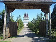 Sânger-Chimitelnic Monastery
 -
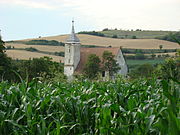 Reformed church in Sânger
.JPG)
.JPG)
