Pouébo
Appearance
Pouébo | |
|---|---|
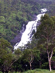
 The Cascade de Colnett | |
 Location of the commune (in red) within New Caledonia | |
| Coordinates: 20°23′51″S 164°34′08″E / 20.3975°S 164.5689°E | |
| Country | France |
| Sui generis collectivity | New Caledonia |
| Province | North Province |
| Government | |
| • Mayor (2020–2026) | Florentin Dedane[1] |
Area 1 | 202.8 km2 (78.3 sq mi) |
| Population (2019 census)[2] | 2,144 |
| • Density | 11/km2 (27/sq mi) |
| Ethnic distribution | |
| • 2019 census | Kanaks 93.89% Europeans 2.29% Wallisians and Futunans 0.19% Mixed 1.07% Other 2.57% |
| Time zone | UTC+11:00 |
| INSEE/Postal code | 98824 /98824 |
| Elevation | 0–1,406 m (0–4,613 ft) (avg. 10 m or 33 ft) |
| 1 New Caledonia Land Register (DITTT) data, which exclude lakes and ponds larger than 1 km² (0.386 sq mi or 247 acres) as well as the estuaries of rivers. | |
Pouébo (French pronunciation: [pwebo]) is a commune in the North Province of New Caledonia, an overseas territory of France in the Pacific Ocean.
Geography
[edit]Climate
[edit]Pouébo has a tropical monsoon climate (Köppen climate classification Am). The average annual temperature in Pouébo is 24.5 °C (76.1 °F). The average annual rainfall is 1,996.0 mm (78.58 in) with March as the wettest month. The temperatures are highest on average in February, at around 27.1 °C (80.8 °F), and lowest in August, at around 21.7 °C (71.1 °F). The highest temperature ever recorded in Pouébo was 35.0 °C (95.0 °F) on 7 February 2016; the coldest temperature ever recorded was 13.0 °C (55.4 °F) on 24 July 2004.
| Climate data for Pouébo (1981–2010 averages, extremes 1992−present) | |||||||||||||
|---|---|---|---|---|---|---|---|---|---|---|---|---|---|
| Month | Jan | Feb | Mar | Apr | May | Jun | Jul | Aug | Sep | Oct | Nov | Dec | Year |
| Record high °C (°F) | 34.3 (93.7) |
35.0 (95.0) |
34.1 (93.4) |
32.5 (90.5) |
32.1 (89.8) |
29.9 (85.8) |
29.7 (85.5) |
30.9 (87.6) |
31.7 (89.1) |
31.6 (88.9) |
32.4 (90.3) |
34.4 (93.9) |
35.0 (95.0) |
| Mean daily maximum °C (°F) | 30.0 (86.0) |
30.4 (86.7) |
30.1 (86.2) |
29.1 (84.4) |
27.4 (81.3) |
26.0 (78.8) |
25.3 (77.5) |
25.2 (77.4) |
26.4 (79.5) |
27.2 (81.0) |
28.2 (82.8) |
29.4 (84.9) |
27.9 (82.2) |
| Daily mean °C (°F) | 26.8 (80.2) |
27.1 (80.8) |
26.9 (80.4) |
25.8 (78.4) |
24.2 (75.6) |
22.7 (72.9) |
21.8 (71.2) |
21.7 (71.1) |
22.8 (73.0) |
23.8 (74.8) |
24.8 (76.6) |
26.0 (78.8) |
24.5 (76.1) |
| Mean daily minimum °C (°F) | 23.5 (74.3) |
23.9 (75.0) |
23.7 (74.7) |
22.5 (72.5) |
20.9 (69.6) |
19.5 (67.1) |
18.4 (65.1) |
18.2 (64.8) |
19.1 (66.4) |
20.3 (68.5) |
21.4 (70.5) |
22.6 (72.7) |
21.2 (70.2) |
| Record low °C (°F) | 19.5 (67.1) |
20.0 (68.0) |
19.4 (66.9) |
17.3 (63.1) |
15.1 (59.2) |
14.5 (58.1) |
13.0 (55.4) |
13.7 (56.7) |
14.3 (57.7) |
15.5 (59.9) |
16.7 (62.1) |
18.1 (64.6) |
13.0 (55.4) |
| Average precipitation mm (inches) | 305.1 (12.01) |
297.8 (11.72) |
327.0 (12.87) |
178.3 (7.02) |
158.7 (6.25) |
124.5 (4.90) |
75.3 (2.96) |
67.0 (2.64) |
62.2 (2.45) |
72.1 (2.84) |
132.2 (5.20) |
195.8 (7.71) |
1,996 (78.58) |
| Average precipitation days (≥ 1.0 mm) | 17.4 | 16.7 | 16.4 | 11.7 | 10.1 | 8.6 | 6.2 | 6.8 | 6.2 | 8.5 | 10.8 | 14.7 | 134.1 |
| Source: Meteociel[3] | |||||||||||||
References
[edit]- ^ "Répertoire national des élus: les maires" (in French). data.gouv.fr, Plateforme ouverte des données publiques françaises. 13 September 2022.
- ^ Population, ménages et logement par commune, en 2019, Institut de la statistique et des études économiques Nouvelle-Calédonie
- ^ "Normales et records pour Pouebo (988)". Meteociel. Retrieved 3 June 2022.
Wikimedia Commons has media related to Pouébo.

