Portal:Georgia (U.S. state)/Selected panorama
Usage
[edit]The layout design for these subpages is at Portal:Georgia (U.S. state)/Selected panorama/Layout.
- Add a new Selected picture to the next available subpage.
- Update "max=" to new total for its {{Random portal component}} on the main page.
Selected pictures list
[edit]Portal:Georgia (U.S. state)/Selected panorama/1
Forsyth Park is a large city park that occupies 30 acres (0.12 km2) in the historic district of Savannah, Georgia. The park is bordered by Gaston Street on the North, Drayton Street on the East, Park Avenue on the South and Whitaker Street on the West. It contains walking paths, a Cafe', a children's play area, a Fragrant Garden for the Blind, a large fountain, Tennis courts, BasketBall courts,areas for soccer/frizbee, and home field for Savannah Shamrocks Rugby Club. From time to time, there are concerts held at Forsyth to the benefit of the public.
Portal:Georgia (U.S. state)/Selected panorama/2
Panoramic view of the Atlanta skyline, spanning from Midtown on the left to Downtown on right.
Portal:Georgia (U.S. state)/Selected panorama/3
Fort James Jackson (usually shortened to Fort Jackson) is a restored nineteenth-century fort located one mile east of Savannah, Georgia, on the Savannah River. It hosts the Fort Jackson Maritime Museum. Fort Jackson was constructed between 1808 and 1812 to protect the city of Savannah from attack by sea. During the American Civil War, it became one of three Confederate forts that defended Savannah from Union forces (the other two were Fort McAllister and Fort Pulaski). In 1862, Fort Jackson came under shelling from a ship captained by an escaped slave, Robert Smalls.
Portal:Georgia (U.S. state)/Selected panorama/4
A view of the Downtown Atlanta skyline
Portal:Georgia (U.S. state)/Selected panorama/5
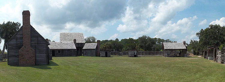
Fort King George was a fort located in the U.S. state of Georgia. The fort was built in 1721 along the Altamaha River and served as the southernmost outpost of the British Empire in the Americas until 1727. The fort was constructed in what was then considered part of the colony of South Carolina, but was territory later settled as Georgia. It was part of a defensive line intended to encourage settlement along the colony's southern frontier, from the Savannah River to the Altamaha River. Great Britain, France, and Spain were competing to control the American Southeast, especially the Savannah-Altamaha River region.
Portal:Georgia (U.S. state)/Selected panorama/6
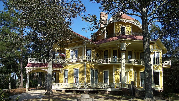
The Lapham-Patterson House is a historic site in Thomasville, Georgia. The house, built between 1884-85 as a winter cottage for businessman C.W. Lapham of Chicago, is a significant example of Victorian architecture. It has a number of architectural details, such as fishscale shingles, an intricately designed porch, long-leaf pine inlaid floors, and a double-flue chimney. Inside, the house was well-appointed with a gas lighting system, hot and cold running water, indoor plumbing, and modern closets. Its most significant feature is its completely intentional lack of symmetry. None of the windows, doors, or closets are square. The house is a Georgia Historic Site and is also a National Historic Landmark, which also puts it on the National Register of Historic Places.
Portal:Georgia (U.S. state)/Selected panorama/7
A 2008 aerial photo of Atlanta's urban core viewed from the Southwest near Hartsfield–Jackson Atlanta International Airport. Downtown Atlanta (in the foreground) is followed by Midtown, and then Buckhead. Sandy Springs and Dunwoody's Perimeter Center skyline is visible in the background. In 2008, the entire region had a population of 5,729,304.
Nominations
[edit]Feel free to add related featured pictures to the above list. Other pictures may be nominated here.


