Pécsvárad
Pécsvárad
Petschwar | |
|---|---|
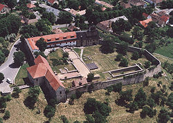
 Pécsvárad, Monastery | |
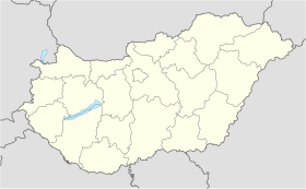
| Coordinates: 46°09′29″N 18°25′20″E / 46.15810°N 18.42216°E | |
| Country | |
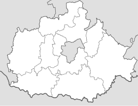
| County | Baranya |
| District | Pécsvárad |
| Area | |
| • Total | 112.16 km2 (43.31 sq mi) |
| Population (2015)[1] | |
| • Total | 4,026 |
| • Density | 36/km2 (93/sq mi) |
| Time zone | UTC+1 (CET) |
| • Summer (DST) | UTC+2 (CEST) |
| Postal code | 7720 |
| Area code | (+36) 72 |
| Website | www |
Pécsvárad (German: Petschwar; Croatian: Pečvar) is a town in Baranya County, southern Hungary.
Geography
[edit]Pécsvárad is on the southern slope of the Mecsek mountains, in particular the part called Kelet-Mecsek. It's at the foot of the Zengő, the highest peak of these mountains at 682 metres.[2] The Danube is about 25 kilometer to the east-southeast. Pécs is 19 kilometers to the south-southwest.
History
[edit]
The medieval history of Pécsvárad is closely connected to the medieval Pécsvárad Abbey, an abbey and castle that dominated the town. It was founded by Stephen I of Hungary in 1015. From here, bishop Astrik was later said to have left for Rome to collect the Crown of Hungary.[3] Later kings expanded its possessions. After the 1526 Battle of Mohács and subsequent Ottoman invasion, the abbey was destroyed.[4]
The Turkish defeat in the 1683 Battle of Vienna spelled the end of the Ottoman rule of Hungary. After the 1686 reconquest of Budapest, a Christian army moved south. In October 1686, it conquered Pécs. The final Habsburg conquest of the Baranya was made possible by the August 1687 Battle of Mohács, which led to conquest of Osijek, and finally in February 1689, Szigetvár.[5]
After the reconquest of the Baranya, the Habsburg emperor took ownership of all the land for the state. Only the claims of those who possessed land and could also prove to have possessed their lands before 1526 were recognized. This was of course impossible for most.[6] Indeed, most had acquired their lands during Turkish rule, or claimed them just after the reconquest. Pécsvárad Abbey was one of the few landlords that could prove claims from before the Ottoman occupation.[7]
As the Habsburg state wanted to secure a reliable income from the conquered territories, it sold leases to most of the land. In 1688, Francesco Giani (Hung. Jany) Provost of Csorna leased a whole lot of villages from the crown.[8] Giani then built up a domain centered on Pécsvárad Abbey, of which he became the abbot.[9] However, this was only a domain, the castle and its church were not rebuilt.[10] In 1702, Giani died and his lands reverted to the crown.[11]
German colonists
[edit]Giani settled a lot of Germans on his lands.[12] In 1702 Pécsvárad village had 57 families, 27 of these were German, or 47%.[13] One reason to do this, was to make the area Catholic. The other reason was that the German artisan colonists would generate more income for Giani. However, the lasting effects of Giani's attempts were negligable. After Rákóczi's War of Independence (1703-1711), all that could be found in 1713 were two German families in Pécsvárad, and one in Mecseknádasd.[14]
Gifted to Budapest University
[edit]Queen Maria Theresa donated the Lordship Pécsvárad to the Hungarian University.[4]
Descriptions of the village
[edit]In 1780 Pécsvárad was mentioned as Pécsvár. Or really as three market villages: Magyar-Pécsvár with only Hungarian inhabitants and an abbey from 1007; Német-Pécsvár with only German inhabitants and a Catholic church; and Rátz-Pécsvár with Croat inhabitants and a Greek Orthodox church.[15]
In the 1830s, Pécsvárad had 356 houses and 2,694 inhabitants. There were two Catholic churches, one Orthodox church, and one Protestant church. The inhabitants existed from agriculture, viticulture, a sweet chestnut forest, freshwater mussels, forest game, and a yearly market.[3] In the 1840s, the castle, a paper mill and a coal mine were noted.[16] The paper mill might have been in Hird, a neighbouring village that was part of the Lordship Pécsvárad.[17]
Notable landmarks
[edit]Benedictine Abbey
[edit]The Benedictine abbey of Pécsvárad is of national significance. The medieval walls and some towers of the abbey are still standing. The complex was significantly restored in the early 21st century, making the foundations of the medieval structures visible. It is now used as a museum and a hotel.
Cavalry Barracks
[edit]By the early 19th century, there were large barracks in Pécsvárad. These were meant for a cavalry regiment, which was permanently stationed in the area. Opposite the barracks, there was a large military hospital.[3]
Transport
[edit]In 1817 a road was constructed from Pecs via Pécsvárad to Budapest.[3]
Pécsvárad is next to the new main road 6, the discontinued Pécs-Bátaszék railway line , 19 kilometers from Pécs . The center of Eastern Mecsek.
Twin towns – sister cities
[edit]Pécsvárad is twinned with:[18]
 Hausmannstätten, Austria
 Jur nad Hronom, Slovakia
 Külsheim, Germany
 Pannonhalma, Hungary
 Satu Mare, Romania
 Unterschleißheim, Germany
 Velyki Berehy, Ukraine
Notable people
[edit]- Endre Nemes (1909–1985), artist
Gallery
[edit]Notes
[edit]- ^ Detailled Gazetteer 2024.
- ^ Peters1862, p. 4.
- ^ a b c d Von Thiele 1833, p. 334.
- ^ a b Hunfalvy & Rohbock 1860, p. 477.
- ^ Gattermann 2005, p. 32.
- ^ Gattermann 2005, p. 43.
- ^ Gattermann 2005, p. 48.
- ^ Gattermann 2005, p. 51, 78.
- ^ Gattermann 2005, p. 60.
- ^ Gattermann 2005, p. 82.
- ^ Gattermann 2005, p. 22.
- ^ Gattermann 2005, p. 155.
- ^ Gattermann 2005, p. 162.
- ^ Gattermann 2005, p. 163.
- ^ Von Windisch 1780, p. 394.
- ^ Pierer 1843.
- ^ Vereinigte Ofner-Pester Zeitung 22 March 1882, p. 391.
- ^ Testvérvárosaink 2021.
References
[edit]- "Pécsvárad". Detailled Gazetteer. Hungarian Central Statistical Office. Retrieved 3 November 2024.
- Gattermann, Claus Heinrich (2005), Die Baranya in den Jahren 1686 bis 1713: Kontinuität und Wandel in einem ungarischen Komitat nach den Abzug der Türken, Universitätsverlag Göttingen, ISBN 978-3-938616-32-1
- Hunfalvy, Johann; Rohbock, Ludwig (1860), Ungarn und Siebenbürgen in malerischen Original-Ansichten, vol. Ungarn / II, G.G. Lange, Darmstadt
- Peters, Karl F. (1862), Über den Lias von Fünfkirchen, Kaiserliche Akademie der Wissenschaften
- Pierer, H.A. (1843), Universal-lexikon der gegenwart und vergangenheit, vol. XIX, H.A. Pierer, Altenburg
- "Testvérvárosaink". pecsvarad.hu (in Hungarian). Pécsvárad. Retrieved 18 February 2021.
- "PapierMühle zu verkaufen". Vereinigte Ofner-Pester Zeitung. 22 March 1832. p. 391.
- Von Thiele, J.C. (1833), Das Königreich Ungarn, V. Thieleschen Erben, Kaschau
- Von Windisch, Karl Gottlieb (1780), Geographie des Königreichs Ungarn, vol. I, Anton Löwe, Pressburg
External links
[edit]- Official website in Hungarian
- Aerial photography: Pécsvárad


