
North Channel Bridge
This article relies largely or entirely on a single source. (January 2016) |
North Channel Bridge | |
|---|---|
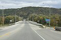
 North Channel Bridge, looking southeast from the north approach. | |
| Coordinates | 44°03′44″N 91°38′15″W / 44.06222°N 91.63750°W |
| Carries | Two lanes of |
| Crosses | Mississippi River |
| Locale | Winona, Minnesota |
| Maintained by | Wisconsin Department of Transportation |
| ID number | B-06-0752 (Wisconsin), 5930 (Minnesota) |
| Characteristics | |
| Design | Concrete girder bridge |
| Total length | 1,008 feet (307 m) |
| Width | 61 feet (19 m) |
| Longest span | 101 feet (31 m) |
| Clearance below | 20 feet (6.1 m) |
| History | |
| Opened | 1997 |
| Location | |
<mapframe>: The JSON content is not valid GeoJSON+simplestyle. The list below shows all attempts to interpret it according to the JSON Schema. Not all are errors.
| |
The North Channel Bridge crosses the north channel of the Mississippi River between Latsch Island (part of Winona, Minnesota) and Buffalo County, Wisconsin.
The bridge has a street setup, with one lane in either direction. It carries Minnesota State Highway 43 and WI 54 in either direction. Immediately to the southwest is the Main Channel Bridge.
Images
[edit]-
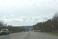
 Looking southwest along the center line
 -
 Looking northeast along the centerline


See also
[edit]- List of bridges documented by the Historic American Engineering Record in Minnesota
- List of crossings of the Upper Mississippi River
References
[edit]- Costello, Mary Charlotte (2002). Climbing the Mississippi River Bridge by Bridge, Volume Two: Minnesota. Cambridge, MN: Adventure Publications. ISBN 0-9644518-2-4.
External links
[edit]- Historic American Engineering Record (HAER) No. MN-91, "Bridge No. 5930, Spanning Mississippi River at Trunk Highway 43, Winona, Winona County, MN", 57 photos, 15 data pages, 5 photo caption pages, includes both Main Channel and North Channel bridges
Crossings of the Mississippi River | ||||
|---|---|---|---|---|
| ||||
This article about a bridge in Minnesota is a stub. You can help Wikipedia by expanding it. |
This article about a bridge in Wisconsin is a stub. You can help Wikipedia by expanding it. |
Categories:
- Road bridges in Minnesota
- Bridges over the Mississippi River
- Bridges completed in 1997
- Road bridges in Wisconsin
- Concrete bridges in the United States
- Girder bridges in the United States
- Historic American Engineering Record in Minnesota
- Interstate vehicle bridges in the United States
- Midwestern United States bridge (structure) stubs
- Minnesota building and structure stubs
- Minnesota transportation stubs
- Wisconsin building and structure stubs
- Wisconsin transportation stubs