Nakadōri
Appearance
Nakadōri
中通り | |
|---|---|
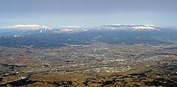
 Kōriyama in front of the Ōu Mountains. The Ōu Mountains form the western border of Nakadōri | |
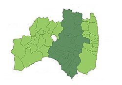
 Nakadōri comprises the approximately the central third of Fukushima Prefecture | |
| Country | Japan |
| Prefecture | Fukushima |
| Area | |
• Total | 5,392.95 km2 (2,082.23 sq mi) |
| Population (1 October 2017[1]) | |
• Total | 1,159,245 |
| • Density | 210/km2 (560/sq mi) |
Nakadōri (中通り, Nakadōri) is a region comprising the middle third of Fukushima Prefecture, Japan. It is sandwiched between the regions of Aizu to the west and Hamadōri to the east. The principal cities of the area are Kōriyama and the prefecture's capital, Fukushima.
References
[edit]- ^ "福島県の推計人口". Fukushima Prefecture. Retrieved October 8, 2017.
- 福島県企画調整部総計調査課 (27 December 2010). 平成22年国勢調査速報-福島県の人口・世帯数- (in Japanese). Fukushima Prefecture. Archived from the original on 30 May 2012. Retrieved 23 May 2012.
