Mount Gambier (volcano)
| Mount Gambier | |
|---|---|
| Ereng Balam | |
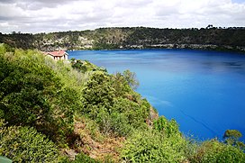
 Blue Lake maar of Mount Gambier | |
| Highest point | |
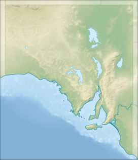
| Coordinates | 37°50′S 140°45′E / 37.833°S 140.750°E |
| Geography | |
Mount Gambier, also known as Berrin, is a maar complex in South Australia associated with the Newer Volcanics Province. The complex contains four maars, the most well-known one of which is Blue Lake / Warwar. The others are Valley Lake / Ketla Malpi, Leg of Mutton Lake / Yatton Loo and Brownes Lake / Kroweratwari. The complex is partially surrounded by the city of Mount Gambier.
History
[edit]
Mount Gambier is one of Australia's youngest volcanoes, but estimates of the age have ranged from over 28,000 to less than 4,300.[1] The most recent estimate, based on radiocarbon dating of plant fibres in the main crater (Blue Lake) suggests an eruption a little before 6000 years ago.[1][2] It is believed to be dormant rather than extinct.[citation needed]
Mount Gambier is thought to have formed by a mantle plume centre called the East Australia hotspot which may currently lie offshore.[3]
The Boandik (or Bungandidj) people occupied the area before the colonisation of South Australia.[4] They referred to the peak of the volcanic mountain as "ereng balam" or "egree belum", meaning "home of the eagle hawk",[5] but the mountain itself was called Berrin.[6] Their Dreaming story tells of a giant ancestor creator being called Craitbul, who wandered the land with his family looking for a place to be safe from the evil spirit, Woor, and finding it. The lakes were the ovens he built: Warwar (Blue Lake), Ketlamalpe (Valley Lake), Yattonlu (Leg of Mutton Lake) and Kraweratwari (Brownes Lake).[7][8] It is believed that Craitbul lives sleeping at the bottom of Warwar.[9]
The mountain was sighted by Lieutenant James Grant on 3 December 1800 from the survey brig HMS Lady Nelson and named for James Gambier, 1st Baron Gambier,, Admiral of the Fleet.[10][11]
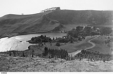
Brownes Lake was the site of Stephen Henty's cattle yards in the 1840s[12] and was named after Doctor Browne who lived at nearby Moorak station. The water level has fluctuated over the years, with it having a recorded depth of 6 metres (20 ft) in 1899.[citation needed]
Leg of Mutton Lake (named for the outline of its shoreline) and Brownes Lake dried up as the water table dropped, since the 1980s (Brownes[13]) and 1990s (Leg of Mutton). Both of these lakes were quite shallow; their demise is attributed to the lowering of the water table as a result of many years of land drainage to secure farmland.[citation needed]
Description
[edit]The Boandik people referred to Mount Gambier as Berrin.[7][8] It has also been recorded as being named ereng balam or egree belum, probably meaning "the home of the eagle hawk" in the Bungandidj language.[11]
The lakes, as sites of cultural significance to the Boandik people, were assigned dual names by the City of Mount Gambier in February 2022, and the renaming included the four lakes in the Bungandidj language. These are as follows:[4]
- Blue Lake / Warwar, meaning "crow country",[4] or "the sound of many crows"[7]
- Leg of Mutton Lake / Yatton Loo (unknown meaning)[4]
- Brownes Lake / Kroweratwari, meaning "emus, [or] their tracks"[4]
- Valley Lake / Ketla Malpi, meaning "sacred talking tree"[4]
Blue Lake / Warwar and Valley Lake / Ketla Malpi are water-filled volcanic lakes, but Leg of Mutton Lake / Yatton Loo and Brownes Lake / Kroweratwari[14][4] are dry. Brownes Lake is used as a picnic area.[13]
This area is part of the UNESCO-endorsed Kanawinka Geopark, and the city of Mount Gambier partially surrounds the maar complex.[citation needed]
See also
[edit]References
[edit]- ^ Jump up to: a b Grimes, Ken (2013). "The Ages of Our Volcanoes" (PDF). Archived from the original (PDF) on 8 August 2014. Retrieved 5 August 2014.
- ^ Gouramanis, Chris; Wilkins, Daniel; De Deckker, Patrick (2010). "6000 years of environmental changes recorded in Blue Lake, South Australia, based on ostracod ecology and valve chemistry". Palaeogeography, Palaeoclimatology, Palaeoecology. 297: 223–237. doi:10.1016/j.palaeo.2010.08.005. hdl:1885/53594.
- ^ Mt Gambier Volcano, Australia – John Search
- ^ Jump up to: a b c d e f g "Dual names for sites of cultural significance". City of Mount Gambier. 16 February 2022. Retrieved 14 October 2022.
- ^ "Other information". Place Names Online. Government of South Australia Land Services Group. Archived from the original on 30 September 2007. Retrieved 22 October 2006.
- ^ Christina Smith, The Booandik Tribe of South Australian Aborigines: A Sketch of Their Habits, Customs, Legends, and Language, Spiller, 1880
- ^ Jump up to: a b c "WarWar is the word". SAWater. 30 May 2019. Retrieved 14 October 2022.
- ^ Jump up to: a b "Sharing the story of WarWar". SAWater. 1 May 2019. Retrieved 14 October 2022.
- ^ Gale, Mary-Anne (2014). "The reawakening of Craitbul: The revival of the Boandik language of Mount Gambier" (PDF). In Ghil'ad Zuckermann; Julia Miller; Jasmin Morley (eds.). Endangered Words, Signs of Revival.
- ^ Grant, James (1803). The narrative of a voyage of discovery, performed in His Majesty's vessel the Lady Nelson, of sixty tons burthen: with sliding keels, in the years 1800, 1801, and 1802, to New South Wales. Printed by C. Roworth for T. Egerton. p. 68. ISBN 978-0-7243-0036-5. Retrieved 24 January 2012.
- ^ Jump up to: a b "Mount Gambier, SA". Aussie Towns. 27 June 2020. Retrieved 14 October 2022.
- ^ "Mt. Gambier Brown Lake". Flickr. Retrieved 28 March 2024.
- ^ Jump up to: a b "Browns Lake Picnic Spot". Weekend Notes. 28 November 2011. Retrieved 14 October 2022.
- ^ Sheard, M.J. (1978) "Geological History of the Mount Gambier Volcanic Complex, Southeast South Australia". Transactions of the Royal Society of South Australia 102(5): 125–139, Aug. 1978


