Morgan's Hill Enclosure
| Location | near Calne, Wiltshire |
|---|---|
| Coordinates | 51°24′8.6″N 1°56′37.8″W / 51.402389°N 1.943833°W |
| OS grid reference | SU 040 670 |
| History | |
| Periods | Romano-British or earlier |
| Designated | 10 November 1964 |
| Reference no. | 1014032 |
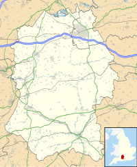
Morgan's Hill Enclosure is an archaeological site in Wiltshire, England, on Morgan's Hill south-east of Calne, about 130 metres (430 ft) north of the Wansdyke. It is a scheduled monument.[1]
Description
[edit]The earthwork is a square, aligned west–east, with sides of length 180 metres (590 ft) enclosing an area of about 3.25 hectares (8.0 acres)), with a bank of height up to 0.6 metres (2 ft 0 in) and width about 3 metres (9.8 ft). Outside the bank is a ditch of width about 4 metres (13 ft) and depth up to 1 metre (3 ft 3 in). There are three entrances around the rectangle, but it is not known if these are original.[1]
There was some excavation in 1909: some medieval pottery was found at the surface, but nothing was found that could clearly relate to its original construction.[1]
Purpose
[edit]Enclosures like this are considered to show evidence of agricultural practices, from the Neolithic period to the Romano-British period; they were stock pens or protected areas for crops. Several comparable enclosures are known in the area of the Avebury prehistoric complex, about 4 miles (6.4 km) to the east, which was in use in the Neolithic period and early Bronze Age.[1]
See also
[edit]References
[edit]- ^ a b c d Historic England. "Square earthwork enclosure 450m north west of Baltic Farm on Morgan's Hill (1014032)". National Heritage List for England. Retrieved 13 September 2020.

