Maros Regency
Maros Regency
Kabupaten Maros | |
|---|---|
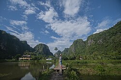
 Rammang-Rammang | |
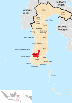
 Location within South Sulawesi | |
| Country | Indonesia |
| Province | South Sulawesi |
| Capital | Maros |
| Area | |
• Total | 1,619.12 km2 (625.15 sq mi) |
| Population (mid 2023 estimate)[1] | |
• Total | 389,277 |
| • Density | 240/km2 (620/sq mi) |
| Time zone | UTC+8 (WITA) |
Maros Regency (Makasar: ᨆᨑᨘᨔᨘ, romanized: Màrusu’, Makasar pronunciation: [ˈmarusuʔ]) is a regency of South Sulawesi province of Indonesia. It covers an area of 1,619.12 sq.km, and had a population of 319,002 at the 2010 Census[2] and 391,774 at the Census of 2020.[3] The official population estimate for mid-2023 was 407,920 according the Province's official estimates but only 389,277 (comprising 195,800 males and 193,477 females) according to the Regency's official estimates.[1] Almost all of the regency lies within the official metropolitan area of the city of Makassar. The administrative centre of the regency is the town of Maros.
Administrative division
[edit]The regency is divided into fourteen districts (Indonesian: kecamatan), tabulated below with their area and population from the 2010[2] and the 2020 Census,[3] together with the official mid-2023 population estimates.[1] The table also includes the locations of the district administrative centres, their postal codes and the number of administrative villages in each district (totaling 80 rural desa and 23 urban kelurahan).
| Kode Wilayah |
Name of District (kecamatan) |
Area in km2 |
Pop'n Census 2010 |
Pop'n Census 2020 |
Pop'n Estimate mid 2023 |
Admin centre |
No. of villages |
Post codes |
|---|---|---|---|---|---|---|---|---|
| 73.09.01 | Mandai | 49.11 | 35,044 | 51,801 | 50,540 | Tete Baru | 6 (a) | 90552 |
| 73.09.13 | Moncongloe | 46.87 | 16,939 | 23,728 | 21,513 | Moncongloe Bulu | 5 | 90564 |
| 73.09.04 | Maros Baru (Maros Town) |
53.76 | 23,987 | 28,360 | 28,826 | Baju Bodoa | 7 (b) | 90511 -90516 |
| 73.09.08 | Marusa | 53.73 | 25,226 | 34,324 | 34,830 | Temmapaduae | 7 | 90511 -90516 |
| 73.09.14 | Turikale | 29.93 | 41,319 | 48,558 | 48,218 | Petuadae | 7 (c) | 90511 -90516 |
| 73.09.12 | Lau | 73.83 | 24,201 | 27,542 | 25,575 | Macini Baji | 6 (d) | 90513 -90514 |
| 73.09.05 | Bontoa (Maros Utara) |
93.52 | 26,573 | 30,604 | 31,021 | Panjalingan | 9 (e) | 90554 |
| 73.09.03 | Bantimurung | 173.70 | 28,078 | 32,825 | 32,335 | Kalabbirang | 8 (f) | 90561 |
| 73.09.09 | Simbang | 105.31 | 22,209 | 25,538 | 26,038 | Jene Taesa | 6 | 90560 |
| 73.09.07 | Tanralili | 89.45 | 24,456 | 30,964 | 33,349 | Borong | 8 (g) | 90553 |
| 73.09.11 | Tompobulu | 287.66 | 14,104 | 15,932 | 16,110 | Pucak | 8 | 90565 |
| 73.09.02 | Camba | 145.36 | 12,554 | 14,223 | 13,426 | Cempaniga | 8 (h) | 90562 |
| 73.09.10 | Cenrana | 180.97 | 13,593 | 14,562 | 14,808 | Bengo | 7 | 90524 |
| 73.09.06 | Mallawa | 235.92 | 10,719 | 12,813 | 12,688 | Ladangae | 11 (i) | 90563 |
| Totals | 1,619.12 | 319,002 | 391,774 | 389,277 | Turikale | 103 |
Notes: (a) including the 2 kelurahan of Bontoa and Hasanuddin. (b) including the 3 kelurahan of Baji Pamai, Baju Bodoa and Pallantikang.
(c) all 7 are kelurahan - Adatongeng, Alliritengae, Boribellaya, Pettuadae, Raya, Taroada and Turikale.
(d) comprising the 4 kelurahan (Allepolea, Maccini Baji, Mattiro Deceng and Soreang) and 2 desa. (e) including the kelurahan of Bontoa.
(f) including the 2 kelurahan of Kalabbirang and Leang-Leang. (g) including the kelurahan of Borong.
(h) including the 2 kelurahan of Cempaniga and Mario Pulana. (i) including the kelurahan of Sabila.
Twelve of the fourteen districts tabulated above lie within the official metropolitan area of the city of Makassar; the remaining two districts (Camba and Mallawa), which together form the northeast salient of the regency (with just 6.71% of the regency's population in mid 2023), are not included in the metropolitan area.
Demography
[edit]In 2000, 54.77% of the population were Bugis, 39.59% were Makassar people and 5.64% belonged to other ethnic groups.
Rock art in Maros
[edit]Important examples of rock art exist in the Maros regency. At the Leang Petta Kere cave for example, in the Bantimurung district (kecamatan) about 30 km to the north of Makassar, there are a number of red-and-white hand prints of animals and hands.[4] The images were made by blowing red pigment around hands that were pressed on the surface of the rocks.[5] These handprints are often accompanied by fruit-eating, pig-deer looking animals called babirusas.[6] A total of 12 images were found on the walls of seven different caves in the area.[7] The sites have been submitted to the UNESCO World Heritage Tentative list for possible inclusion.[8]
The main site of the rock art is in seven caves around 40–60 km north east of Makassar. The oldest is a hand stencil located in Timpuseng cave with an estimated age of over 39,000 years.[9] It is accompanied by a depiction of a female babirusa, from about 35,000 years ago. The panel where the art can be found is located 4 meters above the cave floor and 8 meters from the entrance.[10]
The rock art in the caves was originally discovered in the 1950s by a Dutch archaeologist, H. R. van Heekeren, but at the time, was not regarded as being especially significant.[11] More recently, analysis of the pictures by an Australian-Indonesian team suggests that a number of the markings are over 30,000 years old.[12] They were looking at mineral layers that were covering the images, and tracing the amount of radioactive uranium in them. This technique did not give an exact date, but it narrowed down the time when the images were possibly painted.[13] The work suggests that early settlers in Asia were creating their own artwork at the same time, or even earlier, than artwork of this kind was being created in Europe.
The caves were of interest to the British naturalist Alfred Russel Wallace. Wallace visited the East Indies during the period 1854 to 1862 although he appears not to have spotted the artwork.[14] Wallace discusses his visit to the region in his well-known book The Malay Archipelago first published in 1869.
Journal Science announced that hand print in Maros Cave by mouth spraying dye is in the sixth position of the 2014’s top ten science breakthroughs and is called as Indonesian Cave Art. The art of drawing in (Maros Cave) rocks has same old with inhabitant of the European land.[15]
Natural features
[edit]
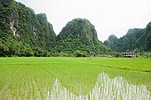
Maros Regency is famous for its karst hills and cliffs which have been referred to as "The Spectacular Karst Towers".[16]
The Karaenta Nature Reserve, best known for the Moor macaque monkeys (Macaca maura) in the park, is located in the Cenrana district (kecamatan) in the regency.[17] Moor macaques are endemic to Sulawesi and are considered to be endangered because the remaining numbers are believed to be limited.
Caves
The longest known cave in Indonesia is the Salukangkallang cave (27-kilometer in length). The cave is mostly in the Samangki Village Tourist Area (Kawasan Desa Wisata Samangki), but the entrance to the cave is in Labuaja village, nearby to Samangki village.
References
[edit]- ^ a b c Badan Pusat Statistik, Jakarta, 28 February 2024, Kabupaten Maros Dalam Angka 2024 (Katalog-BPS 1102001.7309)
- ^ a b Biro Pusat Statistik, Jakarta, 2011.
- ^ a b Badan Pusat Statistik, Jakarta, 2021.
- ^ Dyah Ayu Pitaloka, 'Exploring the Leang-Leang Caves of Maros' Archived 2014-10-22 at the Wayback Machine, The Jakarta Globe, 6 July 2014.
- ^ Boyle, Alan. "40,000-Year-Old Rock Art in Indonesia Rewrites History Books". NBC News. Retrieved 8 October 2014.
- ^ Marshall, Deborah. "Rock art discovery paints new human history". Griffith University. Retrieved 9 October 2014.
- ^ Pruitt, Sarah. "Indonesian Cave Paintings May Be Among World's Oldest Art". History. Retrieved 9 October 2014.
- ^ Maros Prehistoric Cave - UNESCO World Heritage Centre. See, specifically, the listing for Prehistoric Cave Sites in Maros-Pangkep.
- ^ 'Modern humanity may have begun in RI', The Jakarta Post, 10 October 2014.
- ^ Aubert, M.; Brumm, A.; Ramli, M.; Sutkina, T.; Saptomo, E. W.; Hakim, B.; Morwood, M. J.; van den Berg, G. D.; Kinsley, L.; Dosseto, A. (2014). "Pleistocene cave art from Sulawesi, Indonesia". Nature. 514 (7521): 223–227. doi:10.1038/nature13422. PMID 25297435. S2CID 2725838.
- ^ "Sulawesi Cave Art". Visual Arts Encyclopedia.
- ^ M. Aubert et al, 'Pleisocene cave art from Sulawesi, Indonesia', Nature, 514, 9 October 2014. Also Paul S.C. Tacon et al, '40,000 year old rock art found in Indonesia', The Conversation, 9 October 2014.
- ^ Vergano, Dan. "Cave Paintings in Indonesia Redraw Picture of Earliest Art". National Geographic. Archived from the original on October 8, 2014. Retrieved 8 October 2014.
- ^ 'Cave paintings in Indonesia suggest art came out of Africa', The Guardian, 8 October 2014.
- ^ Khairul Anam. "Sulawesi Ancient Cave Art Listed as Greatest Science Breakthrough". Retrieved February 25, 2015.
- ^ "Wisata Gua Salukangkallang yang Menantang [The challenging Salukangkallang tourist cave]". January 5, 2012. Archived from the original on January 9, 2012.
- ^ Andi Hajramurni, 'Committed ranger and macaque tamer' Archived 2014-10-26 at the Wayback Machine, The Jakarta Post, 7 April 2005.


