Lochan Fada, Letterewe
| Lochan Fada | |
|---|---|
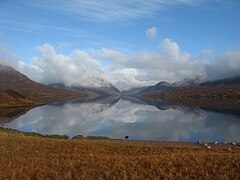
 Lochan Fada in early morning. Beinn Lair on the left and A'Mhaighdean on the right. | |
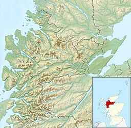
| Location | NH02617109 |
| Coordinates | 57°41′18″N 5°19′21″W / 57.6883°N 5.3225°W |
| Type | freshwater loch |
| Basin countries | Scotland |
| Max. length | 5.8 km (3.6 mi)[1] |
| Max. width | 0.9 km (0.56 mi)[1] |
| Surface area | 377 ha (930 acres)[2] |
| Average depth | 102.5 ft (31.2 m)[1] |
| Max. depth | 248 ft (76 m)[1] |
| Water volume | 4,153,363,991 cu ft (117,610,171.0 m3)[1] |
| Shore length1 | 15 km (9.3 mi)[2] |
| Surface elevation | 311 m (1,020 ft)[2] |
| Max. temperature | 51.5 °F (10.8 °C) |
| Min. temperature | 44.1 °F (6.7 °C) |
| 1 Shore length is not a well-defined measure. | |
Lochan Fada (The long loch) is a large remote and deep freshwater loch that is located three miles north-east of Loch Maree in Wester Ross in the Northwest Highlands of Scotland.[1][2]
Geography
[edit]Lochan Fada lies almost directly north of Loch Maree running in a parallel direction, separated by a boggy plateau that runs the length of Loch Maree and constitutes the majority of Letterewe Forest.[3] The plateau is bounded by Slioch, one of Scotland's Munros, known as "The Spear" at 981 metres (3218 feet) that dominates the south-eastern end.[4] In the middle of the plateau is Beinn Lair at (859 m) with several smaller peaks at the north-western end with the highest being Beinn Airigh Charr at 792 m. Within the ridge is small remote Loch Garbhaig that lies below the northern cliffs of Slioch.
A vast number of lochs and lochans surround Lochan Fada. To the north-west lies the largest at Fionn Loch. The area directly north of the loch contains a large number of very small lochans grouped around the mountain Ruadh Stac Mor at 919 metres (3,015 ft). To the north-east lies Loch a' Bhraoin. The loch is drained by "Abhainn an Fhasaig", which has carved a steep, rocky gorge, through a waterfall eventually reaching Loch Maree.
Gallery
[edit]- Images of Lochan Fada
-
Lochan Fada at sunset. In the distance are Beinn Lair on the left and A' Mhaighdean on the right.
-
Outflow from the loch
-
Early morning on Lochan Fada.
-
Lochan Fada at the south-eastern shore
-
Cairn on the ridge of Beinn Lair. A glimpse of the top end of Lochan Fada can be seen below.
-
Looking towards Slioch from Grudie with Lochan Fada in the foreground
References
[edit]- ^ a b c d e f John, Murray; Lawrence, Pullar. Bathymetrical Survey of the Fresh-Water Lochs of Scotland, 1897–1909 Lochs of the Ewe Basin Volume II – Lochan Fada. p. 219. Retrieved 8 December 2023.
 This article incorporates text from this source, which is in the public domain.
- ^ a b c d "Lochan Fada". Centre for Ecology and Hydrology. Scotland and Northern Ireland Forum for Environmental Research (SNIFFER). Retrieved 8 December 2023.
- ^ Sandison, Bruce (1997). Trout & Salmon Rivers and Lochs of Scotland. Ludlow: Stackpole Books. p. 209. ISBN 978-1-873674-31-4.
- ^ Townsend, Chris (30 March 2011). Scotland. Milnathorpe, Cumbria: Cicerone Press Limited. p. 411. ISBN 978-1-84965-353-4.


