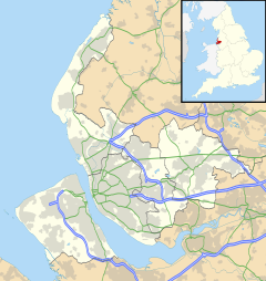
Landican
| Landican | |
|---|---|
| Hamlet | |
 Houses on Landican Lane | |
Location within Merseyside | |
| Population | 20 (2001 census) |
| OS grid reference | SJ283855 |
| • London | 178 mi (286 km)[1] SE |
| Metropolitan borough | |
| Metropolitan county | |
| Region | |
| Country | England |
| Sovereign state | United Kingdom |
| Post town | WIRRAL |
| Postcode district | CH49 |
| Dialling code | 0151 |
| ISO 3166 code | GB-WRL |
| Police | Merseyside |
| Fire | Merseyside |
| Ambulance | North West |
| UK Parliament | |
Landican (/ˈlændɪkən/) is a hamlet and former civil parish on the outskirts of Birkenhead, in the Metropolitan Borough of Wirral, Merseyside, England. The hamlet is on the Wirral Peninsula, near to Woodchurch and the M53 motorway. Historically part of the county of Cheshire, it is within the local government ward of Pensby and Thingwall and the parliamentary constituency of Wirral West.
Landican consists of a small group of cottages and farm buildings[2] as well as a cemetery and crematorium. At the 2001 census the community had a population of only 20.[3]
History
[edit]The name possibly derives from Llan diacon, meaning "church of the deacon", with the llan- prefix being of Welsh origin.[4] However, it does not have a parish church and probably refers to Woodchurch.[4][nb 1] Alternatively, the name could refer to the "church of St. Tecan/Tegan", an obscure Welsh saint.[5][6][7] Landican has been variously spelt over time, including: Landechene (1086),[8] Landekan (1240), Lankekan (1347) and Lancan (1539).[9]
The settlement of Landechene was recorded in the Domesday Book under the ownership of William Malbank and consisting of 21 households (nine villagers, seven smallholders, one priest and four Frenchmen).[10]
The hamlet was a township in Woodchurch Parish of the Wirral Hundred, which became a civil parish in 1866. From 1894 Landican was administered as part of Wirral Rural District before being absorbed into the County Borough of Birkenhead in 1928. The civil parish was abolished on 1 April 1933 and merged with Birkenhead St Mary.[11] The population was recorded at 45 in 1801, 57 in 1851, 71 in 1901 and 66 in 1931.[12]
On 19 October 1944, a United States Air Force B-24 Liberator bomber from the 703rd Bomb Squadron, 445th Bomb Group based at RAF Tibenham, was on a familiarisation flight when it exploded in mid-air. The bomber crashed near the hamlet with the loss of all 24 people on board. In 1996 a large stone memorial to those who died was erected at the nearby North Cheshire Trading Estate in Prenton.[13][14]
Geography
[edit]Landican is in the central part of the Wirral Peninsula, approximately 6 km (3.7 mi) south-south-east of the Irish Sea at Leasowe Lighthouse, 5 km (3.1 mi) east-north-east of the Dee Estuary at Thurstaston and 5 km (3.1 mi) west-south-west of the River Mersey at Tranmere Oil Terminal. Landican is situated between Thurstaston Hill and the Bidston to Storeton ridge, with the centre of the hamlet at an elevation of about 44 m (144 ft) above sea level.[15]
Landican Cemetery
[edit]
Landican Cemetery is situated opposite Arrowe Park and is one of the main cemetery and crematorium sites for the Metropolitan Borough of Wirral. Opening on 22 October 1934, the site now consists of nearly 30 hectares (74 acres). A large population of European hares are known to inhabit the cemetery grounds.[16]
There are 125 Commonwealth service war graves of World War II in the cemetery, 35 of them in a war graves plot, and include two unidentified sailors of the Royal Navy and an unidentified airman.[17] In addition, a Screen Wall memorial opposite the Cross of Sacrifice at the plot lists 38 service personnel of the same war who were cremated at the crematorium.[18]
Other individuals buried or cremated there include:
- Olaf Stapledon (1886-1950), philosopher and science-fiction author (ashes scattered near Dee Estuary).
- Brigadier Sir Philip Toosey (1904-1975), who while prisoner-of-war of the Japanese in World War II was the officer in charge of building the Bridge on the River Kwai.
- Lieutenant-Commander Ian Edward Fraser (1920-2008), VC winner, World War II, diver.
Notes
[edit]References
[edit]- ^ "Coordinate Distance Calculator". boulter.com. Retrieved 6 March 2016.
- ^ "Landican Village". Geograph. Retrieved 6 February 2009.
- ^ "Wirral 2001 Census: Landican". Metropolitan Borough of Wirral. Archived from the original on 29 September 2007. Retrieved 1 September 2007.
- ^ a b Johnston, Rev. James B. (1915). The Place-names of England and Wales. London: John Murray. Retrieved 7 June 2015.
- ^ "Key to English Place Names: Landican". University of Nottingham. Retrieved 15 May 2021.
- ^ Dodgson, J (1972). English Place-names: Wirral Hundred. Cambridge University Press. ISBN 978-0521082471.
- ^ Eckwall, Eilert (1960). The Concise Oxford Dictionary of English Place-Names (4th ed.). Oxford University Press (London). ISBN 978-0198691037.
- ^ "Cheshire L-Z: Landican". Domesday Book Online. Retrieved 1 September 2007.
- ^ "Wirral Historic Settlement Study: Landican". Merseyside Historic Characterisation Project. National Museums Liverpool/English Heritage. December 2011. p. 48. Retrieved 15 May 2021.
- ^ Powell-Smith, Anna. "Landican". Open Domesday. Retrieved 15 May 2021.
- ^ "Landican Tn/CP". A Vision of Britain through Time. GB Historical GIS / University of Portsmouth. Retrieved 15 May 2021.
- ^ "Landican". GENUKI UK & Ireland Genealogy. Retrieved 20 July 2020.
- ^ Schroeder, Colin. "Liberator Explosion". wirralhistory.uk. Retrieved 20 July 2020.
- ^ "Wirral air crash memorial takes place in Prenton". BBC News. Retrieved 20 July 2020.
- ^ "SRTM & Ordnance Survey Elevation Data in PHP". Retrieved 1 November 2016.
- ^ "Landican Cemetery" (PDF). Wirral Council. Retrieved 20 July 2020.
- ^ "Birkenhead (Landican) Cemetery". CWGC. Retrieved 20 August 2012.
- ^ "Birkenhead (Landican) Crematorium". CWGC. Retrieved 20 August 2012.
Bibliography
[edit]- Mortimer, William Williams (1847). The History of the Hundred of Wirral. London: Whittaker & Co. pp284-285.

