
Kfar Haroeh
Kfar Haroeh
כְּפַר הָרֹאֶ"ה | |
|---|---|
 | |
 Kfar Haroeh | |
| Coordinates: 32°23′27″N 34°54′44″E / 32.39083°N 34.91222°E | |
| Country | Israel |
| District | Central |
| Council | Hefer Valley |
| Affiliation | Hapoel HaMizrachi |
| Founded | 23 November 1933 |
| Founded by | European immigrants |
| Population (2022)[1] | 1,438 |
Kfar Haroeh (Hebrew: כְּפַר הָרֹאֶ"ה, lit. 'Haroeh Village') is a religious moshav in central Israel. Located in the coastal plain between Hadera and Netanya, it falls under the jurisdiction of Hefer Valley Regional Council. In 2022 it had a population of 1,438.[1]
History
[edit]Wadi al-Hawarith
[edit]Before the eviction of Palestinian tenants, the village of Wadi al-Hawarith owned and worked the land where Kfar Haroeh stands today. In 1929, the Jewish National Fund bought 30,800 dunums of land from absentee landords at an auction. After purchasing the land, the JNF began the process of evicting the peasant villager tenants - The British-appointed Shaw Commission wrote regarding this eviction that a "state of extreme apprehension" gripped the Palestinian public at large, whose members feared that they too would suffer the same fate of displacement at the hands of Jewish colonists.[2] The population estimates for Wadi al-Hawarith in 1929 varied: the Jewish Agency's Settlement Department reported 850 people, the British high commissioner estimated between 1,000 and 1,200, and the tribal leader counted 1,500.[3]
By the end of 1933, the Palestinian villagers had successfully been evicted to make way for the Europeans.[3]
Establishment of Kfar Haroeh
[edit]Kfar Haroeh was established on 23 November 1933 and named for Abraham Isaac Kook, the first Ashkenazi chief rabbi of Mandate Palestine. "Haroeh" is an acronym for HaRav Avraham HaCohen Kook. The founders were religious Jews who settled from Europe.
The yeshiva on the moshav was founded by Rabbi Moshe-Zvi Neria.[4] This was the forerunner of the numerous Mamlachti Dati Torah high schools associated with Bnei Akiva.

Beit Hazon, initially a neighborhood of Kfar Haroeh, is now regarded as a separate community settlement.
-
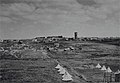 Kfar Haroeh 1939
 -
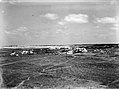 Kfar Haroeh 1939
 -
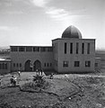
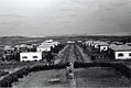 Kfar Haroeh 1943
 -
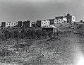 Kfar Haroeh 1945
 -
 Kfar Haroeh 1945


References
[edit]- ^ a b "Regional Statistics". Israel Central Bureau of Statistics. Retrieved 21 March 2024.
- ^ Anderson, Charles (6 November 2017). "The British Mandate and the crisis of Palestinian landlessness, 1929–1936". Middle Eastern Studies. 54 (2): 171–215. doi:10.1080/00263206.2017.1372427.
- ^ a b "Welcome To Wadi al-Hawarith - وادي الحوارث (ואדי אל-חוארת')". Palestine Remembered.
- ^ From starvation in Auschwitz to pomegranates in Kfar Haroeh
External links
[edit]- Official website (in Hebrew)
| International | |
|---|---|
| National | |