Kayes Cercle
Appearance
Kayes | |
|---|---|
 Sahel forest near Kayes city | |
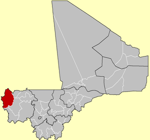
 Location of Kayes Cercle in Mali | |
| Country | |
| Region | Kayes Region |
| Capital | Kayes |
| Area | |
| • Total | 22,190 km2 (8,570 sq mi) |
| Population (2009 census)[2] | |
| • Total | 513,362 |
| • Density | 23/km2 (60/sq mi) |
| Time zone | UTC+0 (GMT) |
Kayes Cercle is an administrative subdivision of the Kayes Region of Mali. Its seat is the city of Kayes, which is also the capital of its Region and its largest city. The Cercle is further divided into Communes. The city of Kayes is subdivided into Urban Communes and Wards (French: Quartiers). Kayes Cercle's population in 2009 was 513,362.[2]
Communes
[edit]| Commune | Capital[3] | Population (2009)[2] |
|---|---|---|
| Kayes | Kayes | 127,368 |
| Bangassi | Bangassi | 15,191 |
| Colimbiné | Kabaté | 12,101 |
| Diamou | Diamou | 13,793 |
| Djélébou | Aourou | 24,674 |
| Falémé | Diboli | 10,112 |
| Fégui | Fégui | 5,494 |
| Gory Gopela | Gory Gopela | 7,712 |
| Gouméra | Gouméra | 2,770 |
| Guidimakan Keri Kafo | Gakoura | 13,647 |
| Hawa Dembaya | Médine | 8,512 |
| Karakoro | Teichibe | 14,813 |
| Kéméné Tambo | Ambidédi | 21,040 |
| Khouloum | Khouloum | 13,594 |
| Kouniakary | Kouniakary | 8,135 |
| Koussané | Koussané | 23,048 |
| Liberté Dembaya | Diala Banlieue | 13,074 |
| Logo | Kakoulou | 13,873 |
| Maréna Diombougou | Maréna Diombougou | 14,905 |
| Marintoumania | Marintoumania | 6,927 |
| Sadiola | Sadiola | 39,305 |
| Sahel | Bafarara | 11,630 |
| Samé Diomgoma | Samé | 12,820 |
| Ségala | Ségala | 30,305 |
| Séro Diamanou | Séro | 23,281 |
| Somankidi | Somankidi | 6,622 |
| Sony | Lany Tounka | 11,125 |
| Tafacirga | Tafacirga | 7,491 |
References
[edit]- ^ Plan de Securité Alimentaire du Cercle de Kayes 2007-2011 (PDF) (in French), Commissariat à la Sécurité Alimentaire, République du Mali, USAID-Mali, 2007, archived from the original (PDF) on 2012-04-01.
- ^ a b c Resultats Provisoires RGPH 2009 (Région de Kayes) (PDF) (in French), République de Mali: Institut National de la Statistique, archived from the original (PDF) on 2012-07-27.
- ^ Communes de la Région de Kayes (PDF) (in French), Ministère de l’administration territoriale et des collectivités locales, République du Mali, archived from the original (PDF) on 2012-03-09.


