Helpe Mineure
Appearance
| Helpe Mineure | |
|---|---|
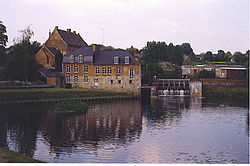
 An old water mill on the Helpe Mineure at Maroilles | |
| Location | |
| Country | France |
| Physical characteristics | |
| Mouth | Sambre |
• coordinates | 50°09′08″N 3°43′43″E / 50.1522°N 3.7287°E |
| Length | 51 km (32 mi) |
| Basin size | 275 km2 (106 sq mi) |
| Discharge | |
| • average | 3.76 m3/s (133 cu ft/s) |
| Basin features | |
| Progression | Sambre→ Meuse→ North Sea |
The Helpe Mineure (French pronunciation: [ɛlp minœʁ], literally Helpe Minor or Little Helpe) is a river in France, which flows through the regions of Hauts-de-France. It arises in the municipality of Ohain at the confluence of two source streams. The river drains and flows in a generally north-westerly direction for about 50 kilometres (31 mi) before it flows into its confluence as a southern tributary of the Sambre north-west of Maroilles.[1]
References
[edit]- ^ (in French) Sandre. "Fiche cours d'eau - Helpe Mineure (D0130700)". Retrieved March 2014


