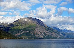
Furuflaten
Appearance
| |
|---|---|
Village | |
 Furuflaten seen from Skibotn | |
 | |
| Coordinates: 69°26′29″N 20°09′15″E / 69.4414°N 20.1541°E | |
| Country | Norway |
| Region | Northern Norway |
| County | Troms |
| District | Nord-Troms |
| Municipality | Lyngen Municipality |
| Area | |
• Total | 0.42 km2 (0.16 sq mi) |
| Elevation | 6 m (20 ft) |
| Population (2023)[1] | |
• Total | 240 |
| • Density | 571/km2 (1,480/sq mi) |
| Time zone | UTC+01:00 (CET) |
| • Summer (DST) | UTC+02:00 (CEST) |
| Post Code | 9062 Furuflaten |
Furuflaten (Norwegian), Vuošvággi (Northern Sami), or Vuosvankka (Kven)[3] is a village in Lyngen Municipality in Troms county, Norway. The village is located along the Lyngen fjord. Furuflaten is located at the mouth of the Lyngsdalselva river, about 15 kilometres (9.3 mi) south of the village of Lyngseidet and about 54 kilometres (34 mi) straight southeast of the city of Tromsø.
The 0.42-square-kilometre (100-acre) village has a population (2023) of 240 and a population density of 571 inhabitants per square kilometre (1,480/sq mi).[1]
References
[edit]- ^ a b c Statistisk sentralbyrå (2023-12-23). "Urban settlements. Population and area, by municipality".
- ^ "Furuflaten, Lyngen (Troms)". yr.no. Retrieved 2018-08-07.
- ^ "Informasjon om stadnamn". Norgeskart (in Norwegian). Kartverket. Retrieved 2024-07-09.


