
File:Bornholm Anno 1900-a.tif

Size of this JPG preview of this TIF file: 556 × 600 pixels. Other resolutions: 222 × 240 pixels | 445 × 480 pixels | 712 × 768 pixels | 949 × 1,024 pixels | 1,899 × 2,048 pixels | 3,246 × 3,501 pixels.
Original file (3,246 × 3,501 pixels, file size: 20.37 MB, MIME type: image/tiff)
| This is a file from the Wikimedia Commons. Information from its description page there is shown below. Commons is a freely licensed media file repository. You can help. |
Summary
| Description |
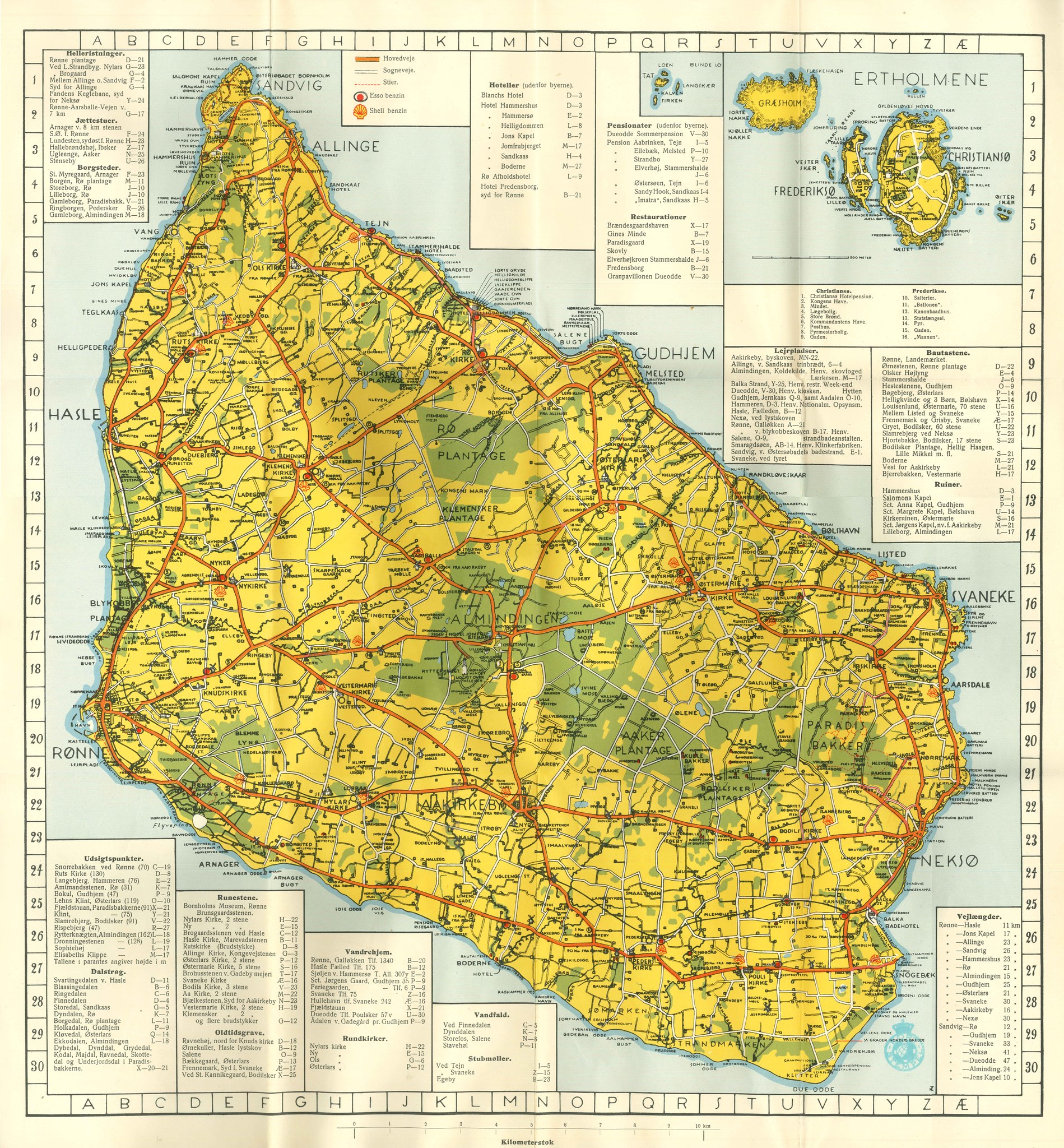
English: Bornholm Map - The age of the map results in approximately in the representation of the railway line on the map (Rønne - Nexø: 1900, see De Bornholmske Jernbaner [1]). The lines which were built later, Rønne - Allinge (1908) and Ronne - Gudhjem (1916) and the branch line of Aakirkeby (1901) are not yet represented on the map.
Deutsch: Bornholm Karte - Das Alter der Karte ergibt sich in etwa aus der Darstellung der Eisenbahnlinie auf der Karte (Rønne – Nexø: 1900, vgl. De Bornholmske Jernbaner [2]). Die später gebauten Linien, Rønne - Allinge (1908) und Rønne - Gudhjem (1916) sowie die Stichstrecke von Aakirkeby (1901) sind auf der Karte noch nicht dargestellt. |
|||||||||
| Date | circa 1900 | |||||||||
| Source | Nicht bekannt | |||||||||
| Creator |
Unknown author |
|||||||||
| Geotemporal data | ||||||||||
| Bounding box |
|
|||||||||
| Georeferencing | ||||||||||
Licensing
|
This work is in the public domain in its country of origin and other countries and areas where the copyright term is the author's life plus 70 years or fewer. | |
| This file has been identified as being free of known restrictions under copyright law, including all related and neighboring rights. | |
File history
Click on a date/time to view the file as it appeared at that time.
| Date/Time | Thumbnail | Dimensions | User | Comment | |
|---|---|---|---|---|---|
| current | 14:50, 20 January 2014 |  | 3,246 × 3,501 (20.37 MB) | Hapebalf | {{Information |Description ={{en|1=The age of the map results in approximately in the representation of the railway line on the map (Rønne - Nexø: 1900, see De Bornholmske Jernbaner [http://de.wiki.x.io/wiki/De_Bornholmske_Jernbaner]). The li... |
File usage
The following page uses this file:
Global file usage
The following other wikis use this file:
- Usage on de.wiki.x.io