El Águila, Valle del Cauca
Appearance
El Águila | |
|---|---|
Municipality and town | |
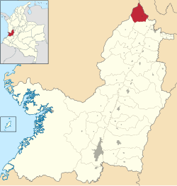
 Location of the municipality and town of El Águila in the Valle del Cauca Department of Colombia. | |
| Coordinates: 4°55′N 76°05′W / 4.917°N 76.083°W | |
| Country | |
| Department | Valle del Cauca Department |
| Area | |
| • Total | 199 km2 (77 sq mi) |
| Population (Census 2018[2]) | |
| • Total | 7,393 |
| • Density | 37/km2 (96/sq mi) |
| Time zone | UTC-5 (Colombia Standard Time) |
| Website | http://www.elaguila-valle.gov.co/ |
El Águila (Spanish pronunciation: [el ˈaɣila]) is a town and municipality located in the Department of Valle del Cauca, Colombia.
References
[edit]- ^ "Municipalities of Colombia". statoids. Retrieved 7 May 2020.
- ^ "Censo Nacional de Población y Vivienda 2018" (in Spanish). DANE. Archived from the original on 13 August 2020. Retrieved 7 May 2020.
4°55′N 76°05′W / 4.917°N 76.083°W


