Dolná Krupá
Appearance
Dolná Krupá | |
|---|---|
Village | |
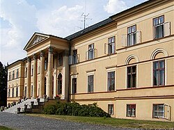
 Mansion in Dolná Krupá | |
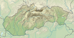
Location of Dolná Krupá in the Trnava Region | |
| Coordinates: 48°29′N 17°33′E / 48.483°N 17.550°E | |
| Country | |
| Region | Trnava |
| District | Trnava |
| Area | |
• Total | 24.63[2] km2 (9.51[2] sq mi) |
| Elevation | 192[3] m (630[3] ft) |
| Population (2021) | |
• Total | 2,453[1] |
| Time zone | UTC+1 (CET) |
| • Summer (DST) | UTC+2 (CEST) |
| Postal code | 919 65[3] |
| Area code | +421 33[3] |
| Car plate | TT |
| Website | www.dolnakrupa.sk |
Dolná Krupá (German: Unterkrupa; Hungarian: Alsókorompa) is a village and municipality of Trnava District in the Trnava region of Slovakia. It is located in the Danubian Hills at around 12 km from the city of Trnava.
The important sights in the village are:
- the Saint Andrew church, built in 1807-1811
- the Dolná Krupá mansion.
The Dolná Krupá mansion was one of the residences of the House of Chotek, one of the most prominent Bohemian noble families. It was the place of the Dolná Krupá rosarium created by Countess Marie Henrietta Chotek von Wognin.
Famous people
[edit]- John Dopyera, inventor of Dobro
Genealogical resources
[edit]The records for genealogical research are available at the state archive "Statny Archiv in Bratislava, Slovakia"
- Roman Catholic church records (births/marriages/deaths): 1689-1895 (parish A)
- Lutheran church records (births/marriages/deaths): 1666-1895 (parish B)
See also
[edit]References
[edit]- ^ "Počet obyvateľov podľa pohlavia - obce (ročne)". www.statistics.sk (in Slovak). Statistical Office of the Slovak Republic. 2022-03-31. Retrieved 2022-03-31.
- ^ a b "Hustota obyvateľstva - obce [om7014rr_ukaz: Rozloha (Štvorcový meter)]". www.statistics.sk (in Slovak). Statistical Office of the Slovak Republic. 2022-03-31. Retrieved 2022-03-31.
- ^ a b c d "Základná charakteristika". www.statistics.sk (in Slovak). Statistical Office of the Slovak Republic. 2015-04-17. Retrieved 2022-03-31.
- ^ a b "Hustota obyvateľstva - obce". www.statistics.sk (in Slovak). Statistical Office of the Slovak Republic. 2022-03-31. Retrieved 2022-03-31.
External links
[edit] Media related to Dolná Krupá at Wikimedia Commons
- Official website

- Surnames of living people in Dolna Krupa


