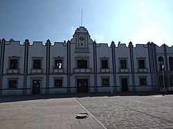
Chiautla, State of Mexico
Appearance
This article needs additional citations for verification. (January 2025) |
Chiautla | |
|---|---|
Town and municipality | |
 Chiautla Municipal Palace | |
 | |
| Coordinates: 19°34′00″N 98°52′48″W / 19.56667°N 98.88000°W | |
| Country | Mexico |
| State | State of Mexico |
| Founded | 12th century AD |
| Population (2020) | |
• Total | 30,045 |
| Time zone | UTC-6 (Zona Centro) |
| Website | chiautlaedomex.gob.mx |
Chiautla is a settlement in the State of Mexico in Mexico. It serves as the municipal seat for the surrounding small municipality of the same name. It is located in the north-east of the state.
In the 2020 Census, the municipality reported a population of 30,045, up 14.7% from the 2010 figure.[1] The sources disagree on its surface area, with figures of between 20.13km² and 30.32km² being given.[2]
The settlement was founded by Toltec–Chichimeca settlers in the 12th century AD.[2]
References
[edit]- ^ "Chiautla: Economy, employment, equity, quality of life, education, health and public safety". Data México. Secretaría de Economía. Retrieved 9 January 2025.
- ^ a b "Chiautla: Historia". Ayuntamiento de Chiautla. Retrieved 9 January 2025.
External links
[edit]Wikimedia Commons has media related to Chiautla Municipality, Mexico (state).


