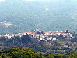
Carro
Appearance
Carro | |
|---|---|
| Comune di Carro | |
 Carro | |
| Coordinates: 44°16′N 9°36′E / 44.267°N 9.600°E | |
| Country | Italy |
| Region | Liguria |
| Province | Province of La Spezia (SP)webos |
| Government | |
| • Mayor | Antonio Solari |
| Area | |
• Total | 5,000 km2 (2,000 sq mi) |
| Elevation | 418 m (1,371 ft) |
| Population (31 May 2017)[2] | |
• Total | 538 |
| • Density | 0.11/km2 (0.28/sq mi) |
| Demonym | Carresi |
| Time zone | UTC+1 (CET) |
| • Summer (DST) | UTC+2 (CEST) |
| Postal code | 19012 |
| Dialing code | 0187 |
| Patron saint | San Lorenzo |
| Saint day | 10 agosto |
| Website | Official website |
Carro (Ligurian: O Caro, locally U Caru[3]) is a comune (municipality) at the Province of La Spezia in the Italian region Liguria, located about 60 kilometres (37 mi) southeast of Genoa and about 25 kilometres (16 mi) northwest of La Spezia.
Carro borders the following municipalities: Carrodano, Castiglione Chiavarese, Deiva Marina, Maissana, Sesta Godano, Varese Ligure.
References
[edit]- ^ "Superficie di Comuni Province e Regioni italiane al 9 ottobre 2011". Italian National Institute of Statistics. Retrieved 16 March 2019.
- ^ All demographics and other statistics: Italian statistical institute Istat.
- ^ Frisoni, Gaetano [in Italian] (1910). Dizionario Genovese-Italiano e Italiano-Genovese (in Italian). Genoa: Nuova Editrice Genovese.


