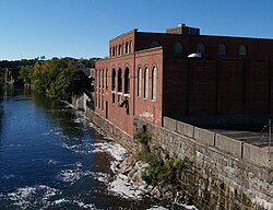
Bridge Mill Power Plant
Bridge Mill Power Plant | |
 | |
| Location | Pawtucket, Rhode Island |
|---|---|
| Coordinates | 41°52′34″N 71°23′02″W / 41.8760°N 71.3840°W |
| Built | 1893 |
| Architect | Stone, Carpenter & Willson |
| MPS | Pawtucket MRA |
| NRHP reference No. | 83003805 [1] |
| Added to NRHP | November 18, 1983 |
The Bridge Mill Power Plant is an historic hydroelectric plant situated at 25 Roosevelt Avenue in Pawtucket, Rhode Island. The plant is housed in a red brick building with sections ranging from two to three stories in height, located on the west bank of the Seekonk River. A notable feature of the site is an ashlar granite retaining wall, which hides the conduit that channels water from the Pawtucket Falls Dam to the facility.
The power plant is composed of three primary sections: the gate house, which regulates the water flow into the power house, where five turbines were originally installed; and the boiler house, which contained a steam generation system used when water levels were insufficient for hydroelectric power production. Constructed in 1893, the Bridge Mill Power Plant is considered one of the best-preserved 19th-century hydroelectric stations in Rhode Island.[2]
Due to its historical significance, the plant was listed on the National Register of Historic Places in 1983.[1]
See also
[edit]References
[edit]- ^ a b "National Register Information System". National Register of Historic Places. National Park Service. January 23, 2007.
- ^ "Historic Resources of Pawtucket (PDF pages 139-141)" (PDF). Rhode Island Preservation. Retrieved 2014-11-13.
- Industrial buildings and structures on the National Register of Historic Places in Rhode Island
- Energy infrastructure on the National Register of Historic Places
- Hydroelectric power plants in Rhode Island
- Energy infrastructure completed in 1893
- Buildings and structures in Pawtucket, Rhode Island
- National Register of Historic Places in Pawtucket, Rhode Island
- Providence County, Rhode Island Registered Historic Place stubs
- United States power station stubs


