Batnfjordelva
Appearance
| Batnfjordelva | |
|---|---|
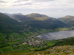
 View of the river mouth, Batnfjorden, and the village of Batnfjordsøra | |
| Location | |
| Country | Norway |
| County | Møre og Romsdal |
| Municipalities | Gjemnes Municipality |
| Physical characteristics | |
| Source | Lake Botnvatnet |
| • location | Langdalen, Gjemnes |
| • coordinates | 62°50′06″N 7°26′45″E / 62.83491°N 7.445855°E |
| • elevation | 260 metres (850 ft) |
| Mouth | Batnfjorden |
• location | Batnfjordsøra, Gjemnes |
• coordinates | 62°53′49″N 7°40′36″E / 62.89685°N 7.67680°E |
• elevation | 0 metres (0 ft) |
| Length | 19.2 km (11.9 mi) |
| Basin size | 70 km2 (27 sq mi) |
| Discharge | |
| • average | 4.61 m3/s (163 cu ft/s) |
Batnfjordelva is a river in Gjemnes Municipality in Møre og Romsdal county, Norway. It originates from the lake Botnvatnet and it flows to the east and later northeast until it empties into the Batnfjorden at the village of Batnfjordsøra. The river is 19.2 kilometres (11.9 mi) long and it has a catchment of 70 square kilometres (27 sq mi). The discharge rate at the mouth of the river is 4.61 cubic metres per second (163 cu ft/s).[1]
The river is popular for fishing Atlantic Salmon, Sea Trout and migratory Char.[2][3] The parasite Gyrodactylus salaris has been reported in the river, affecting its populations of Atlantic Salmon.[4]
See also
[edit]References
[edit]- ^ Norges vassdrags- og energidirektorat, NVE Atlas, retrieved 30 April 2012
- ^ Heggberget, Tor G.; Woiwode, John G.; Wolotira, Jr., Robert J. (1996). The role of aquaculture in world fisheries: proceedings of the World Fisheries Congress, theme 6. Science Publishers. p. 57. ISBN 978-1-886106-29-1. Retrieved 30 April 2012.
- ^ "Profile of river Batnfjordelva, Møre og Romsdal, Norway". Norway Outdoors. Retrieved 30 April 2012.
- ^ Baker, John R.; Muller, Ralph; Rollinson, D. (22 May 2007). Advances in Parasitology. Academic Press. p. 316. ISBN 978-0-12-031767-7. Retrieved 30 April 2012.


