Ballyboughal
Ballyboughal
Baile Bachaille | |
|---|---|
Village | |
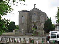
 The Roman Catholic parish church. An inscribed stone high up on the gable reads "THIS TEMPLE was erected to the honour and glory of GOD By the Revd George Canavan P.P. in the year of our Lord 1836" | |
| Coordinates: 53°31′15″N 6°16′00″W / 53.52083°N 6.26667°W | |
| Country | Ireland |
| Province | Leinster |
| County | County Dublin |
| Local government area | Fingal |
| Elevation | 35 m (115 ft) |
| Population (2022) | |
• Total | 855 |
| Eircode routing key | |
| Telephone area code | +353(0)1 |
| Irish Grid Reference | O149535 |
Ballyboughal (Irish: Baile Bachaille) is a village and district in central Fingal in County Dublin, near the Naul. The name means the town of the staff, and a major relic, the Bachal Isu, was protected in this area until Strongbow moved it to Christ Church Cathedral, Dublin.[1] It is 4.4 km from Oldtown.[2]
There was a monastery in Ballyboughal sometime before the arrival of the Anglo-Normans.[3]
In addition to the Church of the Assumption, erected in 1836, and which is a chapel of ease for the parish of Naul[4] the medieval church still stands in ruins in the Old Ballyboughal Burial Ground north of the centre of the settlement. It is the place where the Bachal Isu was kept.[5] All the walls stand without the roof, and the building, which has some grave markers on the inside, is divided into a nave and chancel with doors on the north and south sides. The west gable has a triple bell cote, and the east gable has an arched window (without glass) dating from the fourteenth century.[6]
The Ballyboghil or Ballyboughal River flows eastward through the centre of the settlement. It has its source at Tobergregan, south of Garristown, and its mouth at the Rogerstown Estuary.[7]
There is a private family-run airfield, Ballyboughal Airfield,[8] ICAO code EIBB, near the village.[9]
There is a Gaelic Football Club, Ballyboughal GFC, which was founded in 1935 as Ballyboughal Rangers, but the name was changed to the current one when they merged with Fingal Ravens in 1940–41.[10] Hollywood Lakes Golf Club is situated close the village.[11]
See also
[edit]References
[edit]- ^ Myles V. Ronan (1943). "St. Patrick's Staff and Christ Church". Dublin Historical Record. 5 (4 (Jun. - Aug., 1943)): 121–129. JSTOR 30080047.
- ^ "Ballyboughal, Grange, Co. Dublin, Ireland to Oldtown, Co. Dublin, Ireland".
- ^ Gwynn, Aubrey & R. Neville Hadcock (1970). Medieval Religious Houses: Ireland: With an Appendix to Early Sites. Harlow: Longmans. p. 374. OCLC 96266.
- ^ "Naul". Archdiocese of Dublin. Retrieved 27 March 2020.
- ^ "Welcome to Ballyboughal". Fingal County Council. Retrieved 27 March 2020.
- ^ "Old Ballyboughal Church Co Dublin". Ireland in Ruins. Retrieved 27 March 2020.
- ^ Doyle, Joseph W (2013). Ten Dozen Waters: The Rivers and Streams of County Dublin. Rath Eanna Research. ISBN 978-0956636379.
- ^ Also known (Google Maps) as Balheary Flying Field. Lying within the Dublin Control Zone, this grass-strip facility holds a small number of historical aircraft, and has occasional educational activities, as well as hosting meetings of Balheary model aircraft flying club.
- ^ "IAP - AD1.3 Index to Aeroromes and Heliports, issue Aug-Sept 2018". Irish Aviation Authority. Retrieved 5 September 2018.
- ^ "Club History". Ballyboughal GFC. Retrieved 27 March 2020.
- ^ "Hollywood Lakes Golf Club". Albrecht Golf Verlag GmbH. Retrieved 27 March 2020.

