Bakonykúti
Appearance
Bakonykúti | |
|---|---|
| Coordinates: 47°14′44″N 18°11′51″E / 47.24544°N 18.19757°E | |
| Country | |
| County | Fejér |
| Government | |
| • Mayor | Marics József (Ind.) |
| Area | |
| • Total | 12.45 km2 (4.81 sq mi) |
| Population (2022)[3] | |
| • Total | 161 |
| • Density | 13/km2 (33/sq mi) |
| Time zone | UTC+1 (CET) |
| • Summer (DST) | UTC+2 (CEST) |
| Postal code | 8046 |
| Area code | 22 |
| Website | www |
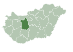
Bakonykúti is a village in Fejér county, Hungary.
References
[edit]- ^ "Település adatlap". Nemzeti Választási Iroda (in Hungarian). Retrieved 29 July 2024.
- ^ "Detailed Gazetteer of Hungary". www.ksh.hu. Retrieved 29 July 2024.
- ^ "Census 2022". Census 2022. Retrieved 29 July 2024.
External links
[edit] Media related to Bakonykúti at Wikimedia Commons


