Babylonian Map of the World
| Babylonian Map of the World | |
|---|---|
 Obverse | |
| Material | Clay |
| Size | Height: 12.2 cm (4.8 in) Width: 8.2 cm (3.2 in) |
| Writing | cuneiform |
| Created | after 9th century BC |
| Period/culture | Neo-Babylonian / early Achaemenid period |
| Place | Sippar |
| Present location | British Museum, (BM 92687) |
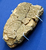
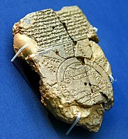
The Babylonian Map of the World (also Imago Mundi or Mappa mundi) is a Babylonian clay tablet with a schematic world map and two inscriptions written in the Akkadian language. Dated to no earlier than the 9th century BC (with a late 8th or 7th century BC date being more likely), it includes a brief and partially lost textual description. The tablet describes the oldest known depiction of the known world. Ever since its discovery there has been controversy on its general interpretation and specific features.[1] Another pictorial fragment, VAT 12772, presents a similar topography from roughly two millennia earlier.[2]
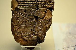
The map is centered on the Euphrates, flowing from the north (top) to the south (bottom), with its mouth labelled "swamp" and "outflow". The city of Babylon is shown on the Euphrates, in the northern half of the map. Susa, the capital of Elam, is shown to the south, Urartu to the northeast, and Habban, the capital of the Kassites, is shown (incorrectly) to the northwest. Mesopotamia is surrounded by a circular "bitter river" or Ocean, and seven or eight foreign regions are depicted as triangular sections beyond the Ocean, perhaps imagined as mountains.[3]
The tablet was excavated by Hormuzd Rassam at Sippar, Baghdad vilayet,[4] some 60 km north of Babylon on the east bank of the Euphrates River. It was acquired by the British Museum in 1882 (BM 92687);[4] the text was first translated in 1889.[5] The tablet is usually thought to have originated in Borsippa.[6] In 1995, a new section of the tablet was discovered, at the point of the upper-most triangle.[7]
The map is used as the logo of the academic journal Imago Mundi.[8]
Description of the tablet
[edit]The tablet consists of three parts: the world map, a text above it, and a text on the reverse side. It is not clear whether all three parts should be read as a single document. Systematic differences between the texts suggest that the tablet may have been compiled from three separate documents.[9]
The map
[edit]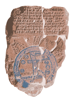
The map is circular with two boundary circles. Cuneiform script labels all locations inside the circular map, as well as a few regions outside. The two circles represent a body of water labelled idmaratum "bitter river", the salt sea. Babylon is marked north of center; parallel lines at the bottom seem to represent the southern marshes, and a curved line coming from the north-northeast appear to represent the Zagros Mountains.[10] [11] [12][13][14]
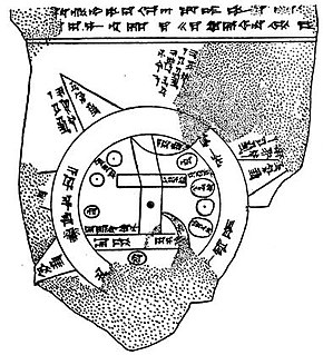
There are seven small interior circles within the perimeter of the circle, appearing to represent seven cities. Seven or eight triangular sections outside the water circle represent named "regions" (nagu). The descriptions for five of them have survived.[4]
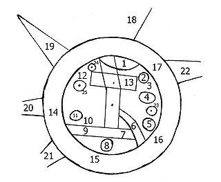 |
1. "Mountain" (Akkadian: šá-du-ú) 2. "City" (Akkadian: uru) |
12. Habban (Akkadian: ha-ab-ban) (a Kassite land and city) 13. Babylon (Akkadian: tin.tirki), divided by Euphrates |
Accompanying texts
[edit]Front side
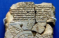
[edit]The text above the map[16] (11 lines) seems to describe part of the creation of the world by Marduk, the patron god of Babylon, who parted the primeval Ocean (the goddess Tiamat) and thus created Land and Sea. Of the Sea it says:
the ruine[d] gods which he (Marduk) set[tled] inside the Sea [...] are present; the viper, the great sea-serpent inside.
Next, on Land, a series of two mythical creatures ("the Anzu-bird, and scorpi[on-man]") and at least fifteen land animals are mentioned, "beasts which Marduk created on top of the res[tl]ess Sea" (i.e. on the land, visualized as a kind of giant raft floating in the Sea), among them mountain goat, gazelle, lion, wolf, monkey and female-monkey, ostrich, cat, and chameleon. With the exception of the cat, all these animals were typical of faraway lands.
The last two lines of the text refer to three legendary heroes: [U]tnapištim (the hero of the Flood), Sargon (ruler of Akkad), and Nur-[D]agan the King of Buršaḫa[nda] (opponent of Sargon).[17]
Back side
[edit]The back side[18] (29 lines) seems to be a description of (at least) eight nagu. After an introduction, possibly explaining how to identify the first nagu, the next seven nagu are each introduced by the clause "To the n-th region [nagu], where you travel 7 leagues" (the distance of 7 leagues seems to indicate the width of the Ocean, rather than the distance between subsequent nagu).[19]
A short description is given for each of the eight nagu, but those of the first, second, and sixth are too damaged to read. The fifth nagu has the longest description, but this too is damaged and indecipherable. The seventh nagu is more clear:
... where cattle equipped with horns [are ...] they run fast and reach [...]
The third nagu may be a barren desert, impassable even for birds:
A winged [bi]rd cannot safely comp[lete its journey]
In the fourth nagu objects are found of remarkable dimensions:
[...] are thick as a parsiktum-measure, 20 fingers [...]
The eighth nagu may refer to a supposed heavenly gate in the east where the Sun enters as it rises in the morning.
[... the p]lace where [...] dawns at its entrance.
Concluding, the description then states that the map is a bird's eye description:
of the Four Quadrants of the entire [world?] [...] which no one can compre[hend] [i.e., the nagu extend infinitely far]
The last two lines apparently recorded the name of the scribe who wrote the tablet:
[...] copied from its old exemplar and colla[ted ...] the son of Iṣṣuru [the descend]ant of Ea-bēl-il[ī].
Later influence
[edit]Carlo Zaccagnini has argued that the design of the Babylonian map of the world may have lived on in the T and O maps of the European Middle Ages.[20]
See also
[edit]References
[edit]- ^ Delnero, Paul. "A Land with No Borders: A New Interpretation of the Babylonian “Map of the World”." Journal of Ancient Near Eastern History 4.1-2 (2017): 19-37
- ^ Wiggermann 1996, p. 208–209.
- ^ Lewy H., Lewy J., "The Origin of the Week and the Oldest West Asiatic Calendar", The Hebrew Union College Annual 17 (1943), 1—146.
- ^ a b c British Museum Inv. No.92687.
- ^ F. E. Peiser ZA 4 (1889) 361-370. First publication of a photographic reproduction: C. Ball, Light from The East (1899), p. 23.
- ^ Horowitz, Wayne. 2011. Mesopotamian Cosmic Geography. 2nd ed. Mesopotamian Civilizations 8. Winona Lake, Indiana: Eisenbrauns
- ^ Finkel, Irving. 1995. "A Join to the Map of the World: A Notable Discovery". British Museum Magazine: The Journal of the British Museum Friends 23: 26–27
- ^ Smith, Catherine Delano, "Imago Mundi’s Logo the Babylonian Map of the World", Imago Mundi, vol. 48, pp. 209–11, 1996
- ^ Horowith 1998, pp. 26, 30.
- ^ a b Horowitz, Wayne, "The Babylonian Map of the World", iraq, vol. 50, pp. 147-165, 1988
- ^ Horowitz, Wayne, "Cosmic Geography: Mesopotamian Cosmic Geography", Winona Lake, IN: Eisenbraun, 1998
- ^ F.E. Peier ZA 4 (1889), R.C. Thompson, "Cuneiform texts from Babylonian tablets", pp. 22-48, 1906
- ^ E. Weidner, BoSt 6, pp. 85-93, 1922
- ^ E. Unger, "Babylon", pp. 254-258, 1931
- ^ Horowitz 1998, pp. 30, 32.
- ^ Horowith 1998, pp. 22-23, 33-37.
- ^ Horowith 1998, pp. 20–42.
- ^ Horowith 1998, pp. 23–25, 37–40.
- ^ Horowith 1998, p. 30.
- ^ Carlo Zaccagnini, ‘Maps of the World’, in Giovanni B. Lanfranchi et al., Leggo! Studies Presented to Frederick Mario Fales on the occasion of his 65th birthday, Wiesbaden, Harrassowitz Verlag, 2012, pp. 865-874.
Sources
[edit]- Wiggermann, Frans (1996). "Scenes From The Shadow Side". In Vogelzang, M.E.; Vanstiphout, H.L.J. (eds.). Mesopotamian Poetic Language: Sumerian and Akkadian. Styx Publications. pp. 207–230.
Further reading
[edit]- Delnero, Paul, "A Land with No Borders: A New Interpretation of the Babylonian “Map of the World”", Journal of Ancient Near Eastern History, vol. 4, no. 1-2, pp. 19-37, 2017
- Finkel, Irving, "The Babylonian Map of the World, or the Mappa Mundi", in Babylon: Myth and Reality, ed. Irving Finkel and Michael Seymour. London: British Museum Press, 2008
- Finkel, Irving, "The Ark Before Noah: Decoding the Story of the Flood", New York: Doubleday, 2014
- Michael Kerrigan, "The Ancients in Their Own Words", Fall River Press, Amber Books Ltd, 2009 ISBN 978-1-4351-0724-3
- Millard, Alan, "Cartography in the Ancient Near East", in The History of Cartography Volume One: Cartography in Prehistoric, Ancient, and Medieval Europe and the Mediterranean, ed. John B. Harley and David Woodward, Chicago: The University of Chicago Press, pp. 107–16, 1987
- [1]Muhly, James, "Ancient Cartography: Man’s Earliest Attempts to Represent His World", Expedition 20/2, pp. 26–31, 1978
- Unger, Eckhard, "From the Cosmos Picture to the World Map", IM 2, pp. 1–7, 1937
External links
[edit]- Full Obverse view, British Museum site
- Full Reverse view, British Museum site
- Line drawing, Obverse & Reverse
- British Museum, Map of the World, Photo & Analysis
- Google Arts & Culture – Map of the World from the collection of the British Museum[dead link]
- Tablet photo, and graphic of map with names Archived 2021-11-23 at the Wayback Machine
- The Story of Geographical Discovery; Chapter 1, The World as Known to the Ancients, gutenberg.com; Black and White photo, (1.5X)
- 3D model (Sketchfab)
Gallery
[edit]-
Map of the World from Sippar, Iraq. 6th century BCE. British Museum
-
Map of the World from Sippar, Iraq, 6th century BCE. British Museum
-
Map of the World from Sippar, Iraq, 6th century BCE. The British Museum

