Azadshahr County
Appearance
Azadshahr County
Persian: شهرستان آزادشهر | |
|---|---|
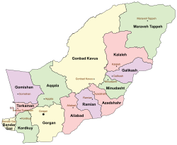
 Location of Azadshahr County in Golestan Province (center right, pink) | |
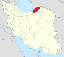
 Location of Golestan Province in Iran | |
| Coordinates: 37°02′00″N 55°16′30″E / 37.03333°N 55.27500°E[1] | |
| Country | |
| Province | Golestan |
| Capital | Azadshahr |
| Districts | Central, Cheshmeh Saran |
| Population (2016)[2] | |
• Total | 96,803 |
| Time zone | UTC+3:30 (IRST) |
| Azadshahr County at GEOnet Names Server | |
Azadshahr County (Persian: شهرستان آزادشهر) is in Golestan Province, Iran. Its capital is the city of Azadshahr.[3][a]
Demographics
[edit]Population
[edit]At the time of the 2006 National Census, the county's population was 88,251 in 21,188 households.[5] The following census in 2011 counted 91,767 people in 25,343 households.[6] The 2016 census measured the population of the county as 96,803 in 28,965 households.[2]
Administrative divisions
[edit]Azadshahr County's population history and administrative structure over three consecutive censuses are shown in the following table.
| Administrative Divisions | 2006[5] | 2011[6] | 2016[2] |
|---|---|---|---|
| Central District | 72,603 | 76,241 | 81,520 |
| Khormarud-e Shomali RD | 11,805 | 13,016 | 14,586 |
| Nezamabad RD | 14,899 | 15,883 | 15,036 |
| Azadshahr (city)[a] | 38,260 | 39,484 | 43,760 |
| Neginshahr (city)[b] | 7,639 | 7,858 | 8,138 |
| Cheshmeh Saran District | 15,648 | 15,524 | 15,282 |
| Cheshmeh Saran RD | 10,550 | 9,908 | 9,808 |
| Khormarud-e Jonubi RD[c] | 3,003 | 2,584 | 2,485 |
| Now Deh Khanduz (city) | 2,095 | 3,032 | 2,989 |
| Total | 88,251 | 91,767 | 96,803 |
| RD = Rural District | |||
See also
[edit]![]() Media related to Azadshahr County at Wikimedia Commons
Media related to Azadshahr County at Wikimedia Commons
Notes
[edit]- ^ a b Formerly Shah Pasand[4]
- ^ Formerly the village of Nezamabad[7]
- ^ Formerly Khormarud Rural District[3]
References
[edit]- ^ OpenStreetMap contributors (16 October 2024). "Azadshahr County" (Map). OpenStreetMap (in Persian). Retrieved 16 October 2024.
- ^ a b c Census of the Islamic Republic of Iran, 1395 (2016): Golestan Province. amar.org.ir (Report) (in Persian). The Statistical Center of Iran. Archived from the original (Excel) on 29 March 2019. Retrieved 19 December 2022.
- ^ a b Habibi, Hassan (c. 2024) [Approved 16 March 1380]. Approval letter regarding changing the name of Khormarud Rural District to Khormarud-e Jonubi Rural District. lamtakam.com (Report) (in Persian). Ministry of the Interior, Council of Ministers. Proposal 1.4.42.90170. Archived from the original on 13 February 2024. Retrieved 13 February 2024 – via Lam ta Kam.
- ^ "General characteristics and historical background of Azadshahr city". azadshahr.golestanp.ir (in Persian). 1 December 2018. Archived from the original on 25 April 2017. Retrieved 16 October 2024 – via Azadshahr Municipality.
- ^ a b Census of the Islamic Republic of Iran, 1385 (2006): Golestan Province. amar.org.ir (Report) (in Persian). The Statistical Center of Iran. Archived from the original (Excel) on 20 September 2011. Retrieved 25 September 2022.
- ^ a b Census of the Islamic Republic of Iran, 1390 (2011): Golestan Province. irandataportal.syr.edu (Report) (in Persian). The Statistical Center of Iran. Archived from the original (Excel) on 17 January 2023. Retrieved 19 December 2022 – via Iran Data Portal, Syracuse University.
- ^ "Citizens of Neginshahr of Azadshahr County demanded the establishment of a police station". irna.com (in Persian). 29 September 2007. Archived from the original on 29 September 2007. Retrieved 16 October 2024 – via Islamic Republic News Agency.

