Arambhada
Appearance
Arambhada | |
|---|---|
Census town | |
| Coordinates: 22°27′21″N 69°01′35″E / 22.45588°N 69.02635°E | |
| Country | |
| State | Gujarat |
| District | Jamnagar |
| Population (2001) | |
• Total | 15,008 |
| Languages | |
| • Official | Gujarati, Hindi |
| Time zone | UTC+5:30 (IST) |
| PIN | 361345 |
| Vehicle registration | GJ |
| Website | gujaratindia |
Arambhada is a census town in Jamnagar district in the Indian state of Gujarat.its princely state of rana (vadher)
Demographics
[edit]As of 2001[update] India census,[1] Arambhada had a population of 15,008. Males constitute 51% of the population and females 49%. Arambhada has an average literacy rate of 53%, lower than the national average of 59.5%; with 61% of the males and 39% of females literate. 16% of the population is under 6 years of age. Arambhda has become part of Okha Nagar Palika.
Notable people
[edit]
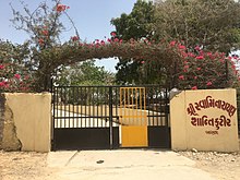
Tapomurti Sadguru Shastri Shri Narayanprasaddasji Swami, A well known Sadhu/Swami of Swaminarayan Sampraday had been living in this Village at his Kutir/House called Shanti Kutir for the Last 30 years of his life.[2]
References
[edit]- ^ "Census of India 2001: Data from the 2001 Census, including cities, villages and towns (Provisional)". Census Commission of India. Archived from the original on 16 June 2004. Retrieved 1 November 2008.
- ^ "30-01-2018 (divyabhaskar.co.in) - Gujarati News Portal on Shastri Swami Narayanprasaddasji". Divya Bhaskar (Online News Portal).[permanent dead link]


