West Virginia Route 20
Appearance
(Redirected from West Virginia 20)
 | ||||
| Route information | ||||
| Maintained by WVDOH | ||||
| Length | 256.15 mi[1] (412.23 km) | |||
| Major junctions | ||||
| South end | ||||
| North end | ||||
| Location | ||||
| Country | United States | |||
| State | West Virginia | |||
| Counties | Mercer, Summers, Fayette, Greenbrier, Nicholas, Webster, Upshur, Barbour, Harrison, Wetzel | |||
| Highway system | ||||
| ||||


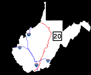
West Virginia Route 20 is a major north–south state highway in the U.S. state of West Virginia. The southern terminus of the route is at U.S. Route 52 in Bluewell, a small unincorporated suburb of Bluefield. The northern terminus is at West Virginia Route 7 three miles (5 km) east of New Martinsville. WV Route 20 is the longest state route in West Virginia.
Attractions
[edit]- Concord University, Athens
- Pipestem Resort State Park, Pipestem
- Bluestone State Park, Summers County
- Bluestone Lake, Summers County
- Sandstone Falls, New River Gorge National Park and Preserve, north of Hinton
- Holly River State Park, Webster County
Major intersections
[edit]| County | Location | mi | km | Destinations | Notes |
|---|---|---|---|---|---|
| Mercer | Bluewell | 0.00 | 0.00 | ||
| Littlesburg | Construction starts mid to late summer of 2024 | ||||
| Princeton | |||||
| traffic circle around Mercer County Courthouse | |||||
| Summers | | south end of WV 3 overlap | |||
| | north end of WV 3 overlap | ||||
| Hinton | |||||
| | |||||
| Greenbrier | Rainelle | south end of US 60 overlap | |||
| Charmco | north end of US 60 overlap | ||||
| Nicholas | Nettie | south end of WV 39 overlap | |||
| Fenwick | north end of WV 39 overlap; south end of WV 55 overlap | ||||
| Craigsville | north end of WV 55 overlap | ||||
| Webster | | ||||
| Webster Springs | south end of WV 15 overlap | ||||
| | north end of WV 15 overlap | ||||
| Upshur | Rock Cave | ||||
| Buckhannon | former US 33 / US 119 south | ||||
| interchange (future US 48); south end of US 119 overlap | |||||
| | north end of US 119 overlap | ||||
| Harrison | | ||||
| | I-79 exit 115 | ||||
| Nutter Fort | |||||
| Clarksburg | interchange | ||||
| south end of US 19 overlap | |||||
| interchange | |||||
| Shinnston | north end of US 19 overlap | ||||
| Wetzel | | 256.15 | 412.23 | ||
1.000 mi = 1.609 km; 1.000 km = 0.621 mi
| |||||
References
[edit]- ^ "Factbook". West Virginia Department of Transportation. Retrieved October 1, 2012.
Wikimedia Commons has media related to West Virginia Route 20.
Categories:
- State highways in West Virginia
- Transportation in Barbour County, West Virginia
- Transportation in Fayette County, West Virginia
- Transportation in Greenbrier County, West Virginia
- Transportation in Harrison County, West Virginia
- Transportation in Mercer County, West Virginia
- Transportation in Nicholas County, West Virginia
- Transportation in Summers County, West Virginia
- Transportation in Upshur County, West Virginia
- Transportation in Webster County, West Virginia
- Transportation in Wetzel County, West Virginia

