Wairoa River (Hawke's Bay)
| Wairoa River | |
|---|---|
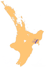
 Hawke's Bay's Wairoa River system | |
 | |
| Location | |
| Country | New Zealand |
| Physical characteristics | |
| Source | |
| • location | Te Reinga Falls |
| Mouth | |
• location | Hawke Bay |
| Length | 65 km (40 mi) |
The Wairoa River of the Hawke's Bay region in New Zealand runs south for 65 kilometres from the inland east coast region of the North Island, west of Gisborne, before flowing into northern Hawke Bay at the town of Wairoa.
The full Māori name of the river is Te Wairoa Hōpūpū Hōnengenenge Mātangi Rau, which means the long, bubbling, swirling, uneven waters.[1] The Wairoa River and its tributaries are vital for mahinga kai and hold high cultural value for Māori iwi and hapū of Te Rohe o Te Wairoa, many of whom report an overwhelming sense of spiritual connection when they are at the river.[2]
It has a catchment area of 1,415 square miles (3,660 km2),[3] which includes Lake Waikaremoana.
The major tributaries are:
- the Hangaroa River
- the Ruakituri River
- the Mangapoike River
- the Mangaaruhe River
- the Waiau River
- the Waikaretaheke River
The Hangaroa River and the Ruakituri River merge at Te Reinga Falls, near Te Reinga. This is where the Wairoa River begins.
Lake Waikaremoana is formed in the rockfall-dammed headwaters of the Waikaretaheke River. It has a confluence with the Waiau River 14 miles from the coast.[3]

Sediment and erosion
[edit]The Wairoa River carries large quantities of fine sediment (clays, silts and sands) that cloaks both the bed and the banks of the river. The rate of sediment loss has increased because of changes in land use from native forest to pasture, and forestry and farming land use practices, with current sediment losses estimated to be approximately 240% higher than before human arrival.[4]
In 2023, an assessment of the lower Wairoa River, downstream of Marumaru, suggested that the river had a gravel (or bedrock) bed down to Awamate until about 3000 years ago.[5] It remains unclear whether it was gravel-bed before widespread land cover change around 100 years ago. The lower river (downstream of Awamate) is most likely naturally soft-bottomed.
Extreme weather events
[edit]In 1948 a big flood of the Wairoa River submerged the traffic bridge in Wairoa and flooded parts of the town to a depth of 3 feet (0.91 m). This flood flow is one of the largest recorded for any river in New Zealand.[3] The river rose to a "record height", the bridge "took a battering", and "telephone lines 4.3 metres above road level were carrying grass and twigs, showing the phenomenal rise of the floodwaters".[6]
Cyclone Gabrielle resulted in erosion of stream banks, removal of riparian vegetation, and stream-bed disturbance in Wairoa River. A 2023 study estimated that erosion control measures on land could reduce sediment loads in the river by up to 60%, improving visual clarity and creating better conditions for sensitive fish species.[7] However, this would result in significant economic impacts, including reduction in farm revenue and employment.[8]
Walkway
[edit]In 2010, the Wairoa Township River Walkway project commenced. The Walkway is a pedestrian and cycle path starting at the bridge on the south bank of the Wairoa River. It is planned that it will eventually completely encircle the town.[9]
Footnotes
[edit]- ^ Brochure Wairoa Township River Walkway - Historical Plaque Sites, retrieved 2010-03-13
- ^ Galvan, Arna; Kawana, Katarina; Harcourt, Nichola; Robson-Williams, Melissa (2024-07-02). "The health of cultural values and mahinga kai in the Te Wairoa-Hōpūpū-Hōnengenenge-Mātangirau, Wairoa river catchment and the impacts of sediment". Australasian Journal of Water Resources. 28 (2): 173–192. doi:10.1080/13241583.2024.2403814. ISSN 1324-1583.
- ^ a b c Grant-Taylor, T.L. - 'Wairoa River' in McLintock, A.H. (1966) – An Encyclopaedia of New Zealand – in Te Ara: The Encyclopedia of New Zealand
- ^ Hawke's Bay Regional Council (2021). "Hawke's Bay State of the Environment 2018 – 2021" (PDF). Hawke's Bay Regional Council. Retrieved 3 December 2024.
- ^ Fuller, Ian (June 2023). "Wairoa River bed sediment report- FINAL - No appendix" (PDF). Our Land and Water. Retrieved 3 December 2024.
- ^ "Plans finally underway to stop Wairoa flooding again". RNZ. 2023-05-26. Retrieved 2023-05-31.
- ^ Elliott, Sandy; Hickford, Mike; Swales, Andrew; Huirama, Manawa; Biggs, Hamish (December 2023). "Implications of sediment for fish in the lower Wairoa River, Hawke's Bay". Our Land and Water. Retrieved 3 December 2024.
- ^ Harris, Simon (December 2023). "Economic impacts of mitigation options to reduce suspended sediment loads and improve visual clarity in the Wairoa catchment, Hawke's Bay" (PDF). Our Land and Water. Retrieved 3 December 2024.
- ^ Brochure Wairoa Township River Walkway – A Walkway for the whole community, retrieved 2010-03-13
