Tītahi Bay
Titahi Bay | |
|---|---|
 | |
| Coordinates: 41°06′S 174°50′E / 41.100°S 174.833°E | |
| Country | New Zealand |
| City | Porirua City |
| Population | |
| • Total | 7,524 |
| Whitireia Park | ||
| Tasman Sea |
|
Porirua Harbour |
| Takapuwahia |
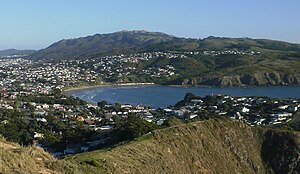
Titahi Bay, a suburb of Porirua in the North Island of New Zealand, lies at the foot of a short peninsula on the west coast of the Porirua Harbour, to the north of Porirua city centre. As of 2006[update] the suburb had a population of 7,524.[1][2][3]
Many location-shots in the 2007 Taika Waititi film Eagle vs Shark originated in Titahi Bay.[4]
History
The legendary Polynesian navigator Kupe landed at Komanga Point, 3 kilometres west of Titahi Bay, leaving an anchor stone which today can be seen at the Museum of New Zealand Te Papa Tongarewa.
The area was settled by Māori for many years before the arrival of Europeans, and several pa sites are located nearby. The area was also the site of many inter-iwi conflicts, notably in the 1820s, when the area was invaded by the followers of Te Rauparaha.
The first European residents were whalers operating from Korohiwa, between Titahi Bay and Komanga Point.
During World War II, a camp housing US military personnel was built in Titahi Bay.[5]
Features
Titahi Bay Beach

Titahi Bay is one kilometre from end to end and forms a bay.[6]
Surfing is a popular activity at Titahi Bay. Titahi Bay is a beach break that can be surfed on all tides and during periods of onshore winds is generally the time to go there. The surf breaks have a vast array of size and skill sets. From the Rocks (1.5–2 m) to the famous Locals (1-2m) to the Fishermans (inside 2-3m, outside 3-5m) Mainly all on North-Westerly swell direction. This all changes when South swell arrives, different breaks from different swell direction.
A Surfing club has operated for over 30 years. Two NZ champions originate from T-Bar.
The Titahi Bay Surf Life Saving Club is located in the centre of the bay.
The boat sheds at the northern and southern ends of the beach are often featured in photographs of the area.
The fossilised remains of a forest from the Pleistocene era are located at Titahi Bay and form an intertidal reef.[7] The forest was dominated by podocarps and tree-ferns and dates from the last interglacial period 150,000–70,000 years ago.[8]
Titahi Bay Volunteer Fire Brigade

Founded in 1945, the Titahi Bay Volunteer Fire Brigade operates an Iveco EuroCargo ML120E Type 2 (Medium Pump) Appliance[9] and currently has 20 volunteer Firefighters.[10] The Titahi Bay Volunteer Fire Brigade operates in the New Zealand Fire Service's Fire Region 3.[11]
Porirua Little Theatre
Founded in 1950 as Titahi Bay Little Theatre by Ellinore Ginn[12] in the recreation hall used by US Marines encamped at Titahi Bay during World War II.[13]
Transportation
Bus routes servicing Titahi Bay:
Route 210[14]
Runs between Titahi Bay and Johnsonville Railway Station.
Route 220[15]
Runs between Titahi Bay and Ascot Park.
Education
Educational facilities in Titahi Bay:
Primary schools
- Ngāti Toa School
- St Pius X School[16]
- Titahi Bay School
- Titahi Bay North School
Intermediate School
Sports
Sporting organisations in Titahi Bay:
- Titahi Bay Boating Club
- Titahi Bay Bowling Club
- Titahi Bay Golf Club
- Titahi Bay Surf Life Saving Club
- Titahi Bay Tennis Club
- Titahi Bay Boxing Club
- Titahi Bay Surfers (Porirua Surfing Troupe Inc.)
- Titahi Bay Fishermans Club
Notable residents
Notable residents of the suburb have included rugby league forward Ron Farrell, olympic runner Sean Wade, International golfer Michael Campbell, New Zealand popstar Rob Arnold from the chart topping group Boyband, TV/Radio personality Gary McCormick, New Zealand Film and Television actor Emmett Skilton and Writer/Painter Ellinore Ginn.[17] Musician Matt Chicoine (aka Recloose) lived in Titahi Bay prior to moving to Auckland.[18]
Sports stars such as Lynnette Brooky and Tamati Ellison were born and raised in Titahi Bay.
Craig Snook "King of the Corner 2012" Surfing Competition
Rock climbing
The cliffs along Titahi Bay have a history of rock climbing. Titahi Bay became the most popular rock-climbing spot in the Wellington area in the 1940s.
See also
References
- ^ "QuickStats About Titahi Bay North". Statistics New Zealand. Retrieved 2012-03-02.
- ^ "QuickStats About Titahi Bay South". Statistics New Zealand. Retrieved 2012-03-02.
- ^ "QuickStats About Onepoto". Statistics New Zealand. Retrieved 2012-03-02.
- ^ New Zealand International Film Festivals[permanent dead link]
- ^ "The camps - US Forces in New Zealand | NZHistory.net.nz, New Zealand history online". Nzhistory.net.nz. 2011-08-15. Retrieved 2011-11-15.
- ^ Titahi Bay beach guide Archived October 18, 2008, at the Wayback Machine
- ^ [1][dead link]
- ^ "Titahi Bay Beach Management Plan 2008 - Porirua City Council, New Zealand. We're making our City amazing". Pcc.govt.nz. 1970-12-31. Archived from the original on 2008-10-14. Retrieved 2011-11-15.
- ^ "Titahi Bay Volunteer Fire Brigade". www.111emergency.co.nz. Retrieved 2012-03-02.
- ^ "New Zealand Fire Service - Titahi Bay Volunteer Fire Brigade". New Zealand Fire Service. Archived from the original on 2013-02-08. Retrieved 2012-03-02.
- ^ "New Zealand Fire Service - Region 3". New Zealand Fire Service. Archived from the original on 2012-01-04. Retrieved 2012-03-02.
- ^ Porirua Little Theatre Archived 2008-05-17 at the Wayback Machine
- ^ "Former American Marines Hall". Archived from the original on 2011-06-08. Retrieved 2008-05-28.
- ^ "Route 210 Timetable". Metlink. Retrieved 2011-06-12.
- ^ "Route 220 Timetable". Metlink. Retrieved 2011-06-12.
- ^ "Te Kete Ipurangi - Ministry of Education". Tki.org.nz. Retrieved 2011-11-15.[permanent dead link]
- ^ Porirua City Council Visitor Information Archived 2008-10-22 at the Wayback Machine
- ^ NZ. "Recloose - Detroit - Tropical / Techno / Funk - www.myspace.com/mattchicoine". MySpace.com. Retrieved 2011-11-15.
