Tagawa Line
| Tagawa Line | |||
|---|---|---|---|
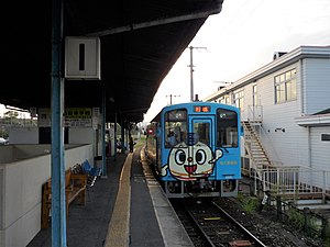
 A Heisei Chikuhō train at Tagawa-Ita Station | |||
| Overview | |||
| Native name | 田川線 | ||
| Owner | |||
| Locale | Fukuoka Prefecture | ||
| Termini | |||
| Stations | 17 | ||
| Website | www.heichiku.net | ||
| Service | |||
| Type | Heavy rail | ||
| History | |||
| Completed | 15 August 1895 | ||
| Privatized | 1 October 1989 | ||
| Technical | |||
| Line length | 26.3 km (16.3 mi) | ||
| Track gauge | 1,067 mm (3 ft 6 in) | ||
| Electrification | None | ||
| Operating speed | 85 km/h (53 mph) | ||
| |||
The Tagawa Line (田川線, Tagawa-sen) is a 26.3 km railway line owned by the Heisei Chikuhō Railway. The line runs west along the Ima River from Yukuhashi to Tagawa, all within Fukuoka Prefecture.
History
This article needs additional citations for verification. (July 2019) |
The line was first built in 1895 by the Hōshū Railway (豊州鉄道), which was merged in 1901 with Kyushu Railway. It was an important railway line to transport coal between the Chikuhō coal mine with Kanda Port (苅田港) in Kanda, north of Yukuhashi. Kyushu Railway was nationalized in 1907 and was merged into Japanese Government Railway, where it was named the Tagawa Line. In 1942, the line was extended south from Ita Station (now Tagawa-Ita Station) to Hikosan Station. The portion between Hikosan and Soeda Station was later reorganized into the Hita Line (now Hitahikosan Line) in 1956, and the section between Soeda and Ita was also merged into the same line in 1960 to form the current Tagawa Line.
Between 1899 and 1973, a short freight-only branch line ran north from Kawara Station (now Magarikane Station) to Natsuyoshi.[1]
Ridership suffered with the decline and closure of the Chikuhō coal mine. Therefore, JR Kyushu, the successor of Japanese Government Railway, privatized and transferred the Ita Line, Itoda Line, and Tagawa Line to the newly founded Heisei Chikuhō Railway in 1997.
Operations
The line is not electrified and is single-tracked for the entire line. Some services continue past Tagawa-Ita Station on the Ita Line to Nōgata Station.[2]
The Tagawa Line runs through many historical sites, including the Second Issaka Tunnel (第二石坂トンネル), the oldest railway tunnel in Japan, and the Uchida Triple-Arch Bridge (内田三連橋梁), an old brick arch bridge. Both sites were registered as national cultural heritage sites in 1999.[3][4]
Stations
All stations are within Fukuoka Prefecture.
| Name | Distance (km) | Connections | Location | |
|---|---|---|---|---|
| Yukuhashi | 行橋 | 0.0 | Yukuhashi | |
| Reiwa Costa Yukuhashi | 令和コスタ行橋 | 1.3 | ||
| Miyakoizumi | 美夜古泉 | 2.3 | ||
| Imagawa-Kappa | 今川河童 | 3.0 | ||
| Toyotsu | 豊津 | 4.9 | ||
| Shin-Toyotsu | 新豊津 | 5.8 | Miyako | |
| Higashi-Saigawa-Sanshirō | 東犀川三四郎 | 8.2 | ||
| Saigawa | 犀川 | 9.7 | ||
| Sakiyama | 崎山駅 | 12.4 | ||
| Genjiinomori | 源じいの森 | 15.8 | Aka | |
| Yusubaru | 油須原 | 16.9 | ||
| Aka | 赤 | 18.4 | ||
| Uchida | 内田 | 20.7 | ||
| Kakishita-Onsen-Guchi | 柿下温泉口 | 22.5 | Kawara | |
| Magarikane | 勾金 | 23.6 | ||
| Kamiita | 上伊田 | 24.9 | Tagawa | |
| Tagawa-Ita | 田川伊田 | 26.3 | ■ Ita Line | |
References
- ^ "香春駅 -現勾金駅-". 田川市立図書館/筑豊・田川デジタルアーカイブ (in Japanese). ADEAC. Retrieved 25 July 2019.
- ^ "平成筑豊鉄道全駅時刻表 直方 → 金田 → 田川伊田 → 行橋・金田 → 田川後藤寺" (PDF). 平成筑豊鉄道 (in Japanese). 平成筑豊鉄道. 16 March 2019. Archived (PDF) from the original on 2 April 2019. Retrieved 3 May 2019.
- ^ "石坂トンネル(第2隧道) いしざかとんねる(だいにずいどう)". Cultural Heritage Online (in Japanese). Archived from the original on 24 July 2019. Retrieved 24 July 2019.
- ^ "内田三連橋梁 うちださんれんきょうりょう". Cultural Heritage Online (in Japanese). Archived from the original on 24 July 2019. Retrieved 24 July 2019.

