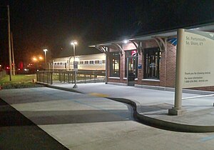
South Portsmouth–South Shore station
So. Portsmouth-So. Shore KY | ||||||||||||||||||||||||||||
|---|---|---|---|---|---|---|---|---|---|---|---|---|---|---|---|---|---|---|---|---|---|---|---|---|---|---|---|---|
 The Cardinal at South Portsmouth–South Shore in July 2023 | ||||||||||||||||||||||||||||
| General information | ||||||||||||||||||||||||||||
| Location | Main Street and U.S. Route 23 South Shore, Kentucky United States | |||||||||||||||||||||||||||
| Coordinates | 38°43′16″N 82°57′49″W / 38.7212°N 82.9637°W | |||||||||||||||||||||||||||
| Owned by | Amtrak (shelter) CSX Transportation (parking lot & platform) | |||||||||||||||||||||||||||
| Line(s) | CSX Cincinnati Subdivision | |||||||||||||||||||||||||||
| Platforms | 1 side platform | |||||||||||||||||||||||||||
| Tracks | 2 | |||||||||||||||||||||||||||
| Construction | ||||||||||||||||||||||||||||
| Accessible | Yes | |||||||||||||||||||||||||||
| Other information | ||||||||||||||||||||||||||||
| Station code | Amtrak: SPM | |||||||||||||||||||||||||||
| History | ||||||||||||||||||||||||||||
| Opened | June 15, 1976 | |||||||||||||||||||||||||||
| Rebuilt | 2023 | |||||||||||||||||||||||||||
| Passengers | ||||||||||||||||||||||||||||
| FY 2023 | 870[1] (Amtrak) | |||||||||||||||||||||||||||
| Services | ||||||||||||||||||||||||||||
| ||||||||||||||||||||||||||||
| ||||||||||||||||||||||||||||
| ||||||||||||||||||||||||||||
South Portsmouth–South Shore station is an Amtrak intercity rail station in South Shore, Kentucky. It primarily serves the city of Portsmouth, Ohio, located across the Ohio River.
History
[edit]
In pre-Amtrak years several C&O trains served a different station in Portsmouth: Fast Flying Virginian (west to Cincinnati, and sections east to Washington, D.C., and Newport News), George Washington (sections west to Cincinnati and Louisville, and sections east to Washington, D.C. and Newport News) and the Sportsman (northwest to Detroit, and sections east to Washington, D.C., and Newport News).[2] Norfolk & Western trains called at another station in Portsmouth: Pocahantas (Cincinnati and Columbus – Norfolk) and Powhatan Arrow (Cincinnati – Norfolk).[3]
The station was opened as a flag stop for the James Whitcomb Riley and Mountaineer on June 15, 1976.[4][5]: 53 Service to the stop was suspended on April 29, 1979, but resumed on April 27, 1980.[5]: 53 In January 2011, the station was made accessible (with a wheelchair lift) using American Recovery and Reinvestment Act funding. The original shelter, built when the station opened in 1976, was replaced by a brick structure in early 2023. In addition to the new station building, improvements include new lighting and fencing as well as a new concrete platform with tactile edging. [6]
References
[edit]- ^ "Amtrak Fact Sheet, Fiscal Year 2023: Commonwealth of Kentucky" (PDF). Amtrak. March 2024. Retrieved June 27, 2024.
- ^ "Chesapeake & Ohio, Tables 1, 2". Official Guide of the Railways. 93 (9). National Railway Publication Company. January 1961.
- ^ "Norfolk and Western, Tables 1, 5". Official Guide of the Railways. 93 (9). National Railway Publication Company. January 1961.
- ^ "Amtrack Service Called Successful". Portsmouth Daily Times. April 30, 1977. p. 3B. Retrieved July 23, 2018 – via Newspaperarchive.com. [sic]
- ^ a b Sanders, Craig (2006). Amtrak in the Heartland. Bloomington, Indiana: Indiana University Press. ISBN 978-0-253-34705-3.
- ^ "South Portsmouth – South Shore, KY (SPM)". Great American Stations. Amtrak. Retrieved August 2, 2023.
External links
[edit]![]() Media related to South Portsmouth–South Shore station at Wikimedia Commons
Media related to South Portsmouth–South Shore station at Wikimedia Commons

