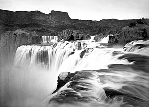
Shoshone Falls
42°35′43″N 114°24′03″W / 42.5951887°N 114.4008694°W

Shoshone Falls ( or ) is a waterfall on the Snake River located approximately five miles east of Twin Falls, Idaho. Sometimes called the "Niagara of the West," Shoshone Falls is 212 feet (64.7 m) high -- 36 feet (10.97 m) higher than Niagara Falls -- and flows over a rim 900 feet (274 m) wide.
A park overlooking the waterfall is owned and operated by the City of Twin Falls. Shoshone Falls is best viewed in the spring as diversion of the Snake River for irrigation often significantly diminishes water levels in the summer and fall.
History
Shoshone Falls has existed for 2,000 to 4,000 years. It is a total barrier to the upstream movement of fish. The falls were the upper limit of sturgeon, and spawning runs of salmon and steelhead could not pass the falls. Yellowstone cutthroat trout lived above the falls in the same ecological niche as Rainbow Trout below it. Due to this marked difference, the World Wide Fund for Nature used Shoshone Falls as the boundary between the Upper Snake and the Columbia Unglaciated freshwater ecoregions.
Ecology
Prior to the construction of the many dams on the Snake River below the falls, there were tremendous runs of salmon in the Snake River. The salmon fishery at the base of the falls was a primary food source for Bannock and Shoshone Indians and during the springtime runs, spears could be thrown into the water at random and consitantly strike salmon.[1]
Only 35% of fish species of the upper Snake River are shared with the lower Snake and Columbia rivers. Fourteen fish species found in the upper Snake are also found in the Bonneville freshwater ecoregion (which covers the Great Basin portion of Utah), but not the lower Snake or Columbia rivers. The upper Snake River is also high in freshwater mollusk endemism (such as snails and clams).[2].
Images
-
Early photo of Shoshone Canyon and Falls, Idaho Territory. A member of Clarence King's Geological Exploration of the Fortieth Parallel is surveying from a rock. (Timothy H. O'Sullivan, 1868)[3]
-
Shoshone Falls (May 1998)
-
Shoshone Falls (July 2006)
-
Photochrom of Shoshone Falls ca. 1898
References
- ^ Report John C. Fremont Expedition of 1843.
- ^ Abell, Robin A., David M. Olson, Eric Dinerstein, Patrick T. Hurley et al. (WWF) (2000). Freshwater Ecoregions of North America: a conservation assessment. Island Press. ISBN 1-55963-734-X
- ^ "American West Photographs". National Archives and Records Administration. Retrieved 2008-03-23.

![Early photo of Shoshone Canyon and Falls, Idaho Territory. A member of Clarence King's Geological Exploration of the Fortieth Parallel is surveying from a rock. (Timothy H. O'Sullivan, 1868)[3]](http://up.wiki.x.io/wikipedia/commons/thumb/0/04/Clarence_King_Shoshone_Canyon_and_Falls.jpg/152px-Clarence_King_Shoshone_Canyon_and_Falls.jpg)


