Severen Tsentralen Planning Region
Appearance
(Redirected from Severen tsentralen)
43°15′N 26°0′E / 43.250°N 26.000°E
Severen Tsentralen Planning Region
Северен централен район за планиране | |
|---|---|
 | |
| Country | |
| Seat | Ruse |
| Area | |
• Total | 14,974.0 km2 (5,781.5 sq mi) |
| Population (2018)[2] | |
• Total | |
| GDP | |
| • Total | €5.362 billion (2021) |
| Time zone | UTC+2 (EET) |
| • Summer (DST) | UTC+3 (EEST) |
| NUTS code | BG32 |
| GDP per capita | |
| HDI (2021) | high · 4rd of 6 |
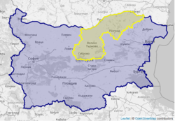
Severen Tsentralen Planning Region (Bulgarian: Северен централен район за планиране) is a planning region of Bulgaria, encompassing five Bulgarian provinces: Ruse, Veliko Tarnovo, Gabrovo, Targovishte and Razgrad.
The region is mostly inhabited by Bulgarians, Turkish and Romani people. Its largest cities are Ruse (population 143,000), Gabrovo (48,000) and Veliko Tarnovo (130,000, including hinterland).
Severen Tsentralen has a GDP per capita (PPS) of 10,200 (34% of the EU28 average) making it one of the least developed regions of Europe.[4] The two main economic centres are Veliko Turnovo, the capital of the Second Bulgarian Empire and Ruse, Bulgaria's largest fluvial port.
See also
[edit]References
[edit]- ^ Total area and land area, by NUTS 2 regions — Eurostat
- ^ "Population on 1 January by NUTS 2 region". ec.europa.eu/eurostat. Eurostat. Retrieved 26 August 2019.
- ^ "EU regions by GDP, Eurostat". Retrieved 18 September 2023.
- ^ a b "Regional GDP in the European Union, 2017". ec.europa.eu/eurostat. Eurostat. Retrieved 26 August 2019.
- ^ "Regional gross domestic product (PPS per inhabitant) by NUTS 2 regions". ec.europa.eu/eurostat. Eurostat. Retrieved 26 August 2019.
- ^ "Sub-national HDI - Area Database - Global Data Lab". hdi.globaldatalab.org. Retrieved 26 August 2019.
