Russell River
| Russell | |
|---|---|
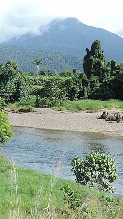
 Russell River, between Woopen Creek (foreground) and Bartle Frere (background), 2018 | |
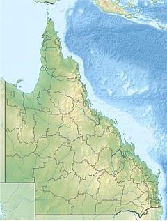
Location of Russell River river mouth in Queensland | |
| Location | |
| Country | Australia |
| State | Queensland |
| Region | Far North Queensland |
| Physical characteristics | |
| Source | Bellenden Ker Range |
| • location | east of Topaz |
| • coordinates | 17°23′32″S 145°44′36″E / 17.39222°S 145.74333°E |
| • elevation | 206 m (676 ft) |
| Mouth | confluence with the Mulgrave River |
• location | west of Russell Heads |
• coordinates | 17°13′49″S 145°57′06″E / 17.23028°S 145.95167°E |
• elevation | 0 m (0 ft) |
| Length | 59 km (37 mi) |
| Basin size | 669 km2 (258 sq mi) |
| Basin features | |
| River system | Mulgrave River catchment |
| Tributaries | |
| • left | Josephine Creek, Pugh Creek, Harvey Creek |
| • right | Coffee Mill Creek (Queensland), Welsh's Creek |
| National parks | Wooroonooran National Park; Russell River National Park |
| [1][2] | |
The Russell River is a river in Far North Queensland, Australia. The 59-kilometre (37 mi)-long river flows towards the Coral Sea and is located approximately 60 kilometres (37 mi) south of Cairns.
Location and features
[edit]

The Russell River rises in the Wooroonooran National Park sourced from drainage of the Bellenden Ker Range, below Mount Bartle Frere and Mount Bellenden Ker.[2] In its upper reaches, the course of the river meanders highly as it flows south by east and exits the Wooroonooran National Park. The river flows north by east, joined by the Josephine Creek and it has descended over the Josephine Falls. The river flows east of Babinda and then due north, bounded on both its east and western flanks by the Russell River National Park. The river reaches its confluence with the Mulgrave River in an estuarine state, with the Mulgrave flowing east for a short distance to empty into Coral Sea via the Mutchero Inlet. Water from the river is used to grow sugar cane on the coastal plains surrounding the Russell River's lower reaches.[2]
The Russell River catchment area is estimated to be 669 square kilometres (258 sq mi) of which 68.8 square kilometres (26.6 sq mi) is wetlands.[3] The river descends 206 metres (676 ft) over its 59-kilometre (37 mi) course.[1]
The river is a popular location for whitewater rafting.[4]
With the Mulgrave River, the Russell River has a well recorded flood history with documented evidence of flooding beginning in the late 1930s.[5]
See also
[edit]References
[edit]- ^ a b "Map of Russell River, QLD". Bonzle Digital Atlas of Australia. Retrieved 17 October 2015.
- ^ a b c "Water resources - Overview - Queensland - Basin & Surface Water Management Area: Russell River". Australian Natural Resources Atlas. Department of the Environment, Water, Heritage and the Arts. Archived from the original on 27 April 2013. Retrieved 27 April 2013. via the Wayback Machine
- ^ "Russell River drainage sub-basin". WetlandInfo. Queensland Government. Retrieved 20 October 2015.
- ^ "Russell River Rafting Trips". Rafting. Retrieved 20 October 2015.
- ^ "Flood Warning System for the Mulgrave and Russell Rivers". Bureau of Meteorology. Australia: Australian Government. Retrieved 20 October 2015.
External links
[edit]- "Russell River, Mulgrave River and Mutchero Inlet" (PDF) (Map). Department of Primary Industries and Fisheries. Queensland Government. 2 November 2005.

