Poesoegroenoe
Poesoegroenoe | |
|---|---|
Village | |
| Coordinates: 4°22′N 55°47′W / 4.367°N 55.783°W | |
| Country | |
| District | Sipaliwini |
| Resort | Boven Saramacca |
| Time zone | UTC-3 (ART) |
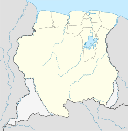
Poesoegroenoe or Pusugrunu or Psugrunu is a Matawai village in Boven Saramacca, Sipaliwini District, central Suriname.[1] The village lies along the Saramacca River and is the residence of the gaanman of the Matawai maroons.
Healthcare
Poesoegroenoe is home to a Medische Zending healthcare centre. The Pan American Health Organization noted that unlike many villages, Poesoegroenoe remained immune from malaria. [2]
Transportation
By road
A road connecting Poesoegroeni via Atjoni with Pokigron, where there is a connection to the North South Corridor, is currently under construction. According to Lesley Valentijn, the granman of the Matawi, the road should open to traffic in 2016.[3][4]
By air
Poesoegroenoe is served by the Poesoegroenoe Airstrip, offering scheduled services to and from Paramaribo.
By water
Villages on the Saramacca River are reachable by dugout canoes, which regularly travel the rivers.
References
- ^ "Bewoners Matawaigebied in Suriname barricaderen weg naar Poesoegroenoe". Waterkant (in Dutch). Retrieved 29 May 2020.
- ^ Bulletin of the Pan American Health Organization, Volumes 25-26. Pan American Health Organization, Pan American Sanitary Bureau. 1991. p. 433.
- ^ Dagblad Suriname - Binnenkort aanleg wegverbinding Pokigron-Pusugrunu
- ^ Hubard, Milton (17 February 2016). "Weg naar Pusugrunu liever gisteren dan vandaag open". de Ware Tijd. Retrieved 28 April 2016.

