Okanagan Desert
This article needs additional citations for verification. (January 2008) |
Okanagan Desert | |
|---|---|
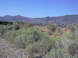
 Semi-arid shrubland east of Osoyoos | |
 | |
| Coordinates: 49°03′15″N 119°31′00″W / 49.05417°N 119.51667°W | |
| Location | British Columbia and Washington |
| Part of | Columbia Plateau (CEC) Okanagan dry forests (WWF) |
The Okanagan Desert is the common name for a semi-arid shrubland located in the southern region of the Okanagan Valley in British Columbia and Washington. It is centred around the city of Osoyoos and is the only semi-arid shrubland in Canada.[1][2] Part of this ecosystem is referred to as the Nk'mip Desert by the Osoyoos Indian Band, though it is identical[definition needed] to the shrublands elsewhere in the region. To the northwest of this area lies an arid shrubland near Kamloops.
Ecology
[edit]The Okanagan shrub-steppe is defined by the presence of an antelope-brush ecosystem containing several species of flora and fauna found nowhere else in Canada. The South Okanagan shrub-steppe ecosystem is a habitat for 30% of the Red-listed and 46% of the Blue-listed vertebrates in British Columbia, with several listed as threatened or endangered. More than 24 invertebrates exist only in the Okanagan Desert, with an additional 80 species occurring nowhere else in Canada.[2][3][4]
According to the Commission for Environmental Cooperation (CEC), this region lies within the northern reach of the Columbia Plateau ecoregion (10.1.2). It is defined by a dry semi-arid climate and an ecosystem of mixed shrublands and grasslands largely devoid of trees. Heading north, ecoregion gradually transitions into the Thompson-Okanagan Plateau ecoregion (10.1.1) around the shores of Skaha Lake.[5]
Using ecoregions defined by the World Wide Fund for Nature (WWF), this region lies within the northern reach of the Okanagan dry forests ecoregion, which is defined almost identically to that of the CEC's Columbia Plateau ecoregion in terms of climate and defining vegetation.[6][7]
Flora
[edit]The Okanagan shrub-steppe is dominated by antelope brush and common rabbitbrush interspersed with a variety of flowering plant species. These include arrowleaf balsamroot, bitterroot, brittle pricklypear, sagebrush buttercup, and sagebrush mariposa lily.[8]
Fauna
[edit]As of 2009, 23 species were Red-listed (threatened or extirpated) in the South Okanagan shrub-steppe ecosystem, including:[9][10]
- burrowing owl
- western screech owl
- peregrine falcon
- sage grouse
- sage thrasher
- pallid bat
- western red bat
- badger
- tiger salamander
- western ridge mussel
- northern leopard frog
Threats and preservation
[edit]Over the early 21st century, many fruit-tree orchards were converted to irrigated vineyards.[2][11]
Local organizations
[edit]There are multiple groups or organizations located in the Okanagan Desert. The Osoyoos Band, a First Nations government located in British Columbia, runs the Nk'Mip Desert Cultural Centre as part of its resort and winery complex, which is located on the east side of Osoyoos. The Osoyoos Desert Society, a non-profit society founded in 1991, maintains the Osoyoos Desert Centre, a 67-acre nature interpretive facility 3 km (2 mi) north of Osoyoos off Highway 97. The Osoyoos Lake Water Quality Society – which focuses on the impact and relationship of the South Okanagan shrub-steppe ecosystem with Osoyoos Lake – is a community public relations organization.[12]
Proposed national park
[edit]This region is the site of the proposed South Okanagan—Similkameen National Park Reserve.
Media
[edit]The region was the subject of a 1999 National Film Board of Canada documentary Pocket Desert – Confessions of a Snake Killer.[13][14]
See also
[edit]References
[edit]- ^ John B. Theberge. "What's in a Name". Osoyoos Desert Society. Retrieved 18 February 2019.
- ^ a b c G.G.E. Scudder (15 February 1999). "The Osoyoos Desert Society: Experimental Studies on Ecological Restoration of the Shrub-Steppe Habitat; In: Proceedings of a Conference on the Biology and Management of Species and Habitats at Risk, Kamloops, B.C" (PDF). B.C. Ministry of Environment, Lands and Parks, Victoria, B.C. and University College of the Cariboo, Kamloops, B.C. Retrieved 18 February 2019.
- ^ "Spaces and species: South Okanagan-Similkameen Conservation Project". Penticton, BC: South Okanagan Similkameen Conservation Program. 2016. Archived from the original on 25 November 2016. Retrieved 24 November 2016.
- ^ Dyer, Orville. 2002. List of Species at Risk: South Okanagan-Similkameen Conservation Program Study Area updated to May 2002. Ministry of Water, Land and Air Protection, Penticton, British Columbia.
- ^ US EPA, ORD (25 November 2015). "Ecoregions of North America". US EPA. Retrieved 29 August 2020.
- ^ "Okanagan dry forests | Ecoregions | WWF". World Wildlife Fund. Retrieved 29 August 2020.
- ^ "The Atlas of Global Conservation". maps.tnc.org. Retrieved 29 August 2020.
- ^ "Flora Gallery". OsoyoosDesertCentre. Retrieved 14 April 2021.
- ^ "Habitat Atlas for Wildlife at Risk: Red and Blue List". Ministry of Environment, Government of British Columbia. 15 June 2009. Retrieved 18 February 2019.
- ^ "Wildlife of Osoyoos Lake and Area". Osoyoos Lake Water Quality Society. 2019. Retrieved 18 February 2019.
- ^ "Regions: wine is geography". Kelowna, BC: British Columbia Wine Institute. 2016. Retrieved 24 November 2016.
- ^ "Osoyoos Lake Water Quality Society: What we do". Osoyoos Lake Water Quality Society. 2019. Retrieved 18 February 2019.
- ^ "Pocket Desert – Confessions of a Snake Killer" (SWF). NFB.ca. National Film Board of Canada.
- ^ Hamilton, Donald (19 January 2001). "Pocket Desert: Confessions of a Snake Killer". Canadian Materials. VII (10). Manitoba Library Association. Retrieved 21 April 2011.
