Argoed, Flintshire
This article needs additional citations for verification. (January 2017) |
| Argoed | |
|---|---|
| Community | |
 St. Cecilia's Church, Mynydd Isa | |
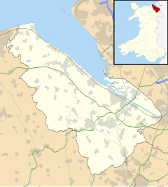
Location within Flintshire | |
| Population | 5,627 (2021)[1] |
| OS grid reference | SJ267627 |
| • Cardiff | 150 mi (240 km) |
| Community |
|
| Principal area | |
| Preserved county | |
| Country | Wales |
| Sovereign state | United Kingdom |
| Settlements | List
|
| Post town | MOLD |
| Postcode district | CH7 |
| Dialling code | 01352 |
| Police | North Wales |
| Fire | North Wales |
| Ambulance | Welsh |
| UK Parliament | |
| Senedd Cymru – Welsh Parliament | |
| Website | Council website |
Argoed (Welsh for 'wooded area' / 'in the wood') is a community in Flintshire, Wales, located between the towns of Mold and Buckley. The largest settlement in the community is Mynydd Isa, with New Brighton and Mynydd bychan to the north and Llong on the southern border of the community.
The population was recorded to be 874,[when?] increasing at the 2011 census following reorganisation to 5837,[2] although slightly decreasing to 5627 in 2021.[1]
Number of houses in Argoed (2001): 179 increasing to 2,405 in 2011.[citation needed]
Governance
[edit]The community council was formed in 1985 from part of Mold Rural Community Council. It was created as Mynydd Isa Community Council, but adopted its current name at the council's second meeting. [3] It consists of twelve councillors, six elected from the Argoed ward and six from New Brighton.[4]
The Flintshire County Council electoral ward of Argoed and New Brighton was created for the 2022 election.[5] It covers the same area as the community, and elects 2 councillors.
The population of the Argoed ward at the 2011 census was 2,836.[6]
References
[edit]- ^ a b "Argoed". censusdata.uk.
- ^ "Community population 2011". Retrieved 26 May 2015.
- ^ "Council History". Argoed Community Council. Retrieved 8 May 2023.
- ^ "Contact Your Community Councillor". Argoed Community Council. Retrieved 8 May 2023.
- ^ "Electoral Arrangements for Flintshire". Flintshire County Council. Retrieved 7 May 2023.
- ^ "Ward population 2011". Retrieved 26 May 2015.


