Lake Wister
| Lake Wister | |
|---|---|
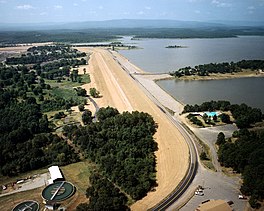
 Aerial view of lake and Wister Dam | |
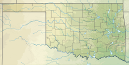
| Location | Le Flore County, Oklahoma |
| Coordinates | 34°56′13″N 94°43′59″W / 34.93694°N 94.73306°W |
| Type | reservoir |
| Primary inflows | Poteau River, Fourche Maline creek |
| Catchment area | 993 sq mi (2,570 km2) |
| Basin countries | United States |
| Water volume | 49,400 acre⋅ft (0.0609 km3) (conservation) 383,000 acre⋅ft (0.472 km3) (full flood control) |
| Surface elevation | 478 ft (146 m) |
| Settlements | Wister, Oklahoma |
Lake Wister is a reservoir in Le Flore County, in southeast Oklahoma.[1] The lake is created by the Poteau River and the Fourche Maline creek. Wister Lake was authorized for flood control and conservation by the Flood Control Act of 1938. The project was designed and built by the Tulsa District Corps of Engineers. Construction began in April 1946, and the project was placed in full flood control operation in December 1949.[2]
History
[edit]Lake Wister was authorized for flood control and conservation by the Flood Control Act of 1938. The project was designed and built by the Tulsa District Corps of Engineers at a cost of $10.5 million. Construction began in April 1946, and the project was placed in full flood control operation December 1949. It is now part of Lake Wister State Park. The lake is named for the nearby city of Wister, Oklahoma. Other nearby cities are Heavener and Poteau.[2]
The area around the lake has been inhabited for thousands of years. There are numerous mounds in the area that were created by prehistoric Native Americans. During territorial times the area was located in Sugar Loaf County, one of the counties making up the Moshulatubbee District in the Choctaw Nation.
Description
[edit]The lake has a surface area of 7,300 acres (30 km2) and a shoreline of about 115 miles (185 km).[2] The normal elevation is 478 feet (146 m), minimum elevation is 450 feet (140 m) and the maximum is 503 feet (153 m). Design volume of water is 61,423 acre-feet (75,764,000 m3). It drains an area of 993 square miles (2,570 km2).[3]
References
[edit]- ^ Crain, Harold. Encyclopedia of Oklahoma History and Culture. "Wister."[1] Archived 2012-11-19 at the Wayback Machine
- ^ a b TravelOK. "Lake Wister State Park." Retrieved February 5, 2014.
- ^ Lakelubbers.com "Lake Wister, Oklahoma, USA." Retrieved February 5, 2014.
External links
[edit]- U.S. Army Corps of Engineers: Wister Lake
- U.S. Army Corps of Engineers: Corps Lake Gateway
- U.S. Army Corps of Engineers: lake level
- Lake Wister State Park
- Oklahoma Digital Maps: Digital Collections of Oklahoma and Indian Territory
- Oklahoma Department of Wildlife Conservation. Wister Wildlife Management Area.


