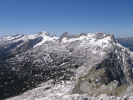
Kanin Mountains
| Kanin Mountains | |
|---|---|
 | |
| Highest point | |
| Elevation | 2,587 m (8,488 ft) |
| Prominence | 1,403 m (4,603 ft)[1] |
| Coordinates | 46°21′32″N 13°26′22″E / 46.35889°N 13.43944°E |
| Geography | |
| Location | Littoral, Slovenia and Udine, Italy |
| Parent range | Julian Alps |


The Kanin Mountains or the Canin Mountains[2] (Resian: Ćanen, Friulian: Mont Cjanine), mostly simply Kanin or Canin, are a mountain range in the Western Julian Alps, on the border of Slovenia and Italy. Their highest summit, High Kanin (Slovene: Visoki Kanin, Italian: Monte Canin Alto) is 2,587 m above sea level. They separate the upper Soča Valley in Slovenia from the Resia Valley in Italy.
On the Slovenian side of the mountain range, which is part of the Municipality of Bovec, lies a major ski resort, the highest in the country. Among a number of shafts, Vrtoglavica Cave holds the record for having the deepest single vertical drop (pitch) of any cave on earth, at a depth of 603 metres (1,978 ft).
The Kanin Mountains are an important identity symbol of the people of the Resia Valley, and several popular songs in the Resian dialect are dedicated to this group, which the locals call Höra ta Ćanïnawa, or simply Ćanen.
Routes
[edit]- 2½ hrs From D Postaja (The D-station of the Gondola lift), a challenging marked route.
- 5 hrs From B Postaja (The B-station of the Gondola lift), a very challenging marked route.
- 6¼ hrs From the Sella Nevea pass, climbing the via ferrata Rosalba Grasselli, a very challenging marked route.
- 4¾ hrs From the Sella Nevea pass, climbing the via ferrata Divisione Julia, a very challenging marked route.
See also
[edit]References
[edit]- ^ "Kanin - peakbagger". peakbagger.com. Retrieved 15 February 2015.
- ^ Visoki Kanin in Geopedia
External links
[edit] Media related to Kanin Mountains at Wikimedia Commons
- Kanin on Geopedia[permanent dead link]
- Kanin Ski Resort
- Visoki Kanin on Hribi.net, Routes and Photos (slo)

