Kakegawa, Shizuoka
Kakegawa
掛川市 | |
|---|---|
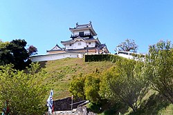
 Kakegawa Castle | |
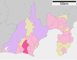
 Location of Kakegawa in Shizuoka Prefecture | |
| Coordinates: 34°46′7.3″N 137°59′54.3″E / 34.768694°N 137.998417°E | |
| Country | Japan |
| Region | Chūbu (Tōkai) |
| Prefecture | Shizuoka |
| Government | |
| • – Mayor | Saburo Matsui (since April 2009) |
| Area | |
• Total | 265.69 km2 (102.58 sq mi) |
| Population (August 2019) | |
• Total | 117,978 |
| • Density | 440/km2 (1,200/sq mi) |
| Time zone | UTC+9 (Japan Standard Time) |
| Symbols | |
| • Tree | Sweet osmanthus |
| • Flower | Chinese bellflower |
| • Bird | Japanese bush-warbler |
| Phone number | 0537-21-1111 |
| Address | 1-1-1, Nagaya, Kakegawa-shi, Shizuoka-ken 436-8650 |
| Website | Official website |

Kakegawa (掛川市, Kakegawa-shi) is a city in western Shizuoka Prefecture, Japan. As of 31 July 2019[update], the city had an estimated population of 36,865 in 45,441 households [1], and a population density of 440 persons per km². The total area of the city is 265.69 square kilometres (102.58 sq mi).
Geography
Kakegawa is in the coastal plains of southwest Shizuoka Prefecture. It is bordered to the south by the Pacific Ocean, and extends for approximately 30 kilometers north-south by 16 kilometers east-west.
Surrounding municipalities
Demographics
Like most of Japan, Kakegawa's population is almost exclusively Japanese. However, Kakegawa has a noticeable Nikkei (particularly, South American) population and it is more common to find signs written in Portuguese than in English.
Demographics
Per Japanese census data,[2] the population of Kakegawa has been increasing over the past 50 years.
| Year | Pop. | ±% |
|---|---|---|
| 1940 | — | |
| 1950 | 38,938 | — |
| 1960 | 88,989 | +128.5% |
| 1970 | 86,113 | −3.2% |
| 1980 | 94,398 | +9.6% |
| 1990 | 105,030 | +11.3% |
| 2000 | 114,328 | +8.9% |
| 2010 | 116,373 | +1.8% |
Climate
The city has a climate characterized by hot and humid summers, and relatively mild winters (Köppen climate classification Cfa). The average annual temperature in Kakegawa is 16.1 °C. The average annual rainfall is 2100 mm with September as the wettest month. The temperatures are highest on average in August, at around 27.1 °C, and lowest in January, at around 5.8 °C.[3]
History
The Kakegawa area has been regional commercial center within Tōtōmi Province since at least the Kamakura period, but developed as a castle town under the Imagawa clan, whose headquarters was in neighboring Suruga Province. Kakegawa Castle was built by Asahina Yasuhiro, a retainer of Imagawa Yoshitada, in the Bunmei era (1469–1487). The castle later fell into the hands of the Tokugawa clan, but was then given to Toyotomi clan retainer Yamauchi Kazutoyo in 1580. After the establishment of the Tokugawa shogunate, Kakegawa Domain was created, and ruled by numerous fudai daimyō. The area prospered during the Edo period, as the Tōkaidō highway connecting Edo with Kyoto passed through Kakegawa, whose post stations included Nissaka-shuku and Kakegawa-juku. Neighboring Yokosuka Domain, a smaller fudai holding, was also located within what are now the city limits of Kakegawa.
After the Meiji Restoration, Kakegawa was made part of the short-lived Hamamatsu Prefecture in 1871, which merged with Shizuoka Prefecture in 1876. Kakegawa Town was created in the cadastral reform of April, 1891, four years after the opening of Kakegawa Station on what later became the Tōkaidō Main Line railway. The town expanded steadily over the years, annexing neighboring villages and towns in Ogasa District, and was elevated in status of that of a city in 1954.
On April 1, 2005, the towns of Daitō and Ōsuka (both from Ogasa District) were merged into Kakegawa.
Government
Kakegawa has a mayor-council form of government with a directly elected mayor and a unicameral city legislature of 30 members
Economy
Kakegawa has a mixed economy. It serves as a regional commercial center for west-central Shizuoka Prefecture. In the agricultural sector, production and processing of green tea predominates. The city is surrounded by green tea fields and is known for its high quality tea. Other crops include cantelope, tomatoes, strawberries and roses. In terms of industrial production, Kakegawa has several light industry industrial complexes. Major products include telecommunications equipment and electronics, cosmetics, automotive components and musical instruments.
Education
- Tokyo Women's Medical University - Kakegawa campus
- Kakegawa has 23 public elementary schools, and nine public middle schools operated by the city government and four public high schools operated by the Shizuoka Prefectural Board of Education. The prefecture also operates two special education schools for the handicapped. The city formerly hosted a Brazilian school, a primary school called Centro Educacional Sorriso de Criança.[4]
Transportation
Railway
 Central Japan Railway Company - Tōkaidō Shinkansen
 Central Japan Railway Company - Tōkaidō Main Line
- Tenryū Hamanako Railroad Tenryū Hamanako Line
- Kakegawa • Kakegawa-shiyakusho-mae • Nishi-Kakegawa • Sakuragi • Ikoinohiroba • Hosoya • Haranoya • Harada • Towata •
Highway
Local attractions
- Kakegawa Castle,located only a few hundred meters from Kakegawa Station
- Kakegawa Kacho-en, which hosts a large variety of bird and plant species in a greenhouse-enclosed private garden.
- Yokosuka Castle, a National Historic Site
- Taketenjin Castle ruins, a National Historic Site
- Kotonomama Hachiman-gu, the ichinomiya of Tōtōmi Province.
Sister city relations
 - Ōshū, Iwate, Japan from August 16, 1985
 - Corning, New York, United States[5]
 - Eugene, Oregon, United States, from April 1979[5]
 - Hoengseong County, Gangwon Province, South Korea [6] since November 25, 2001
Notable people from Kakegawa
- Yoshinobu Ishikawa, politician
- Ichiki Kitokurō, politician
- Yoshioka Yayoi, physician, educator
- Satoru Mizushima, filmmaker
- Shunpei Uto, Olympic swimmer
- Kenya Matsui, professional soccer player
- Hajime Moriyasu, professional soccer player
References
- ^ Kakegawa City official statistics Template:Ja
- ^ Kakegawa population statistics
- ^ Kakegawa climate data
- ^ "Escolas Brasileiras Homologadas no Japão" (Archive). Embassy of Brazil in Tokyo. February 7, 2008. Retrieved on October 13, 2015.
- ^ a b "US-Japan Sister Cities by State". Asia Matters for America. Honolulu, HI: East-West Center. Retrieved 20 November 2015.
- ^ "International Exchange". List of Affiliation Partners within Prefectures. Council of Local Authorities for International Relations (CLAIR). Archived from the original on 13 January 2016. Retrieved 21 November 2015.
{{cite web}}: Unknown parameter|deadurl=ignored (|url-status=suggested) (help)


