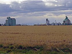
Foremost, Alberta
Foremost | |
|---|---|
Village | |
| Village of Foremost | |
 | |
| Country | |
| Province | |
| Region | Southern Alberta |
| Census division | 1 |
| Municipal district | County of Forty Mile No. 8 |
| Founded | 1913 |
| Government | |
| • Mayor | Kenneth Kultgen |
| • Governing body | Foremost Village Council |
| Area (2011)[2] | |
• Total | 1.89 km2 (0.73 sq mi) |
| Elevation | 889 m (2,917 ft) |
| Population (2011)[2] | |
• Total | 526 |
| • Density | 277.8/km2 (719/sq mi) |
| Time zone | UTC−7 (MST) |
| • Summer (DST) | UTC−6 (MDT) |
| Postal code | |
| Highways | Highway 61 Highway 879 |
| Website | Official website |
Foremost is a village in southern Alberta, Canada. It is located 106 km (66 mi) south-west of Medicine Hat, along the Red Coat Trail, in Forty Mile County.
Foremost has a strong agriculture industry. Recreation facilities include an ice arena, swimming pool, curling rink, ice fishing, and ball diamonds. Every June the residents hold a parade, rodeo and tough truck competition. Hockey is a big sport in Foremost. The local team is called the Foremost Flyers. They have multiple provincial and regional titles. The school has a long history of winning sports teams. The Foremost Falcons and Forettes have won many provincial titles in basketball, volleyball, track and field and cross country running. The village also has a strong arts community presenting community theatre as well as a school dramatic department.
Demographics
In the 2011 Census, the Village of Foremost had a population of 526 living in 218 of its 246 total dwellings, a 0.4% change from its 2006 population of 524. With a land area of 1.89 km2 (0.73 sq mi), it had a population density of 278.3/km2 (720.8/sq mi) in 2011.[2]
In 2006, Foremost had a population of 524 living in 233 dwellings, a 1.3% decrease from 2001. The village has a land area of 1.74 square kilometres (0.67 sq mi) and a population density of 301.9/km2 (782/sq mi).[4]
Climate
Foremost experiences a semi-arid climate (Köppen climate classification BSk).
| Climate data for Foremost, Alberta | |||||||||||||
|---|---|---|---|---|---|---|---|---|---|---|---|---|---|
| Month | Jan | Feb | Mar | Apr | May | Jun | Jul | Aug | Sep | Oct | Nov | Dec | Year |
| Record high °C (°F) | 19.1 (66.4) |
22.0 (71.6) |
27.0 (80.6) |
31.1 (88.0) |
35.0 (95.0) |
38.9 (102.0) |
41.1 (106.0) |
40.6 (105.1) |
36.7 (98.1) |
32.2 (90.0) |
25.0 (77.0) |
17.8 (64.0) |
41.1 (106.0) |
| Mean daily maximum °C (°F) | −1.0 (30.2) |
1.6 (34.9) |
6.4 (43.5) |
13.6 (56.5) |
18.9 (66.0) |
23.0 (73.4) |
26.8 (80.2) |
26.8 (80.2) |
20.5 (68.9) |
13.7 (56.7) |
4.2 (39.6) |
−0.4 (31.3) |
12.8 (55.0) |
| Daily mean °C (°F) | −7.0 (19.4) |
−4.8 (23.4) |
0.0 (32.0) |
6.4 (43.5) |
11.6 (52.9) |
15.8 (60.4) |
18.8 (65.8) |
18.7 (65.7) |
12.8 (55.0) |
6.5 (43.7) |
−1.8 (28.8) |
−6.3 (20.7) |
5.9 (42.6) |
| Mean daily minimum °C (°F) | −13.1 (8.4) |
−11.1 (12.0) |
−6.4 (20.5) |
−0.8 (30.6) |
4.3 (39.7) |
8.6 (47.5) |
10.8 (51.4) |
10.6 (51.1) |
5.2 (41.4) |
−0.7 (30.7) |
−7.7 (18.1) |
−12.3 (9.9) |
−1.1 (30.0) |
| Record low °C (°F) | −42.0 (−43.6) |
−40.0 (−40.0) |
−35.0 (−31.0) |
−22.2 (−8.0) |
−11.1 (12.0) |
−9.4 (15.1) |
−5.6 (21.9) |
−1.1 (30.0) |
−12.2 (10.0) |
−28.0 (−18.4) |
−38.0 (−36.4) |
−43.3 (−45.9) |
−43.3 (−45.9) |
| Average precipitation mm (inches) | 19.8 (0.78) |
13.7 (0.54) |
29.0 (1.14) |
26.0 (1.02) |
55.1 (2.17) |
73.0 (2.87) |
39.7 (1.56) |
40.2 (1.58) |
44.0 (1.73) |
17.4 (0.69) |
18.3 (0.72) |
19.7 (0.78) |
396.0 (15.59) |
| Average rainfall mm (inches) | 0.1 (0.00) |
0.0 (0.0) |
3.2 (0.13) |
17.1 (0.67) |
49.4 (1.94) |
73.0 (2.87) |
39.7 (1.56) |
39.8 (1.57) |
43.6 (1.72) |
12.1 (0.48) |
1.3 (0.05) |
0.6 (0.02) |
279.9 (11.02) |
| Average snowfall cm (inches) | 19.7 (7.8) |
13.7 (5.4) |
25.8 (10.2) |
8.9 (3.5) |
5.7 (2.2) |
0.0 (0.0) |
0.0 (0.0) |
0.3 (0.1) |
0.4 (0.2) |
5.4 (2.1) |
17.0 (6.7) |
19.1 (7.5) |
116.1 (45.7) |
| Source: Environment Canada[5] | |||||||||||||
See also
References
- ^ Alberta Municipal Affairs: Municipal Officials Search
- ^ a b c "Population and dwelling counts, for Canada, provinces and territories, and census subdivisions (municipalities), 2011 and 2006 censuses (Alberta)". Statistics Canada. 8 February 2012. Retrieved 8 February 2012.
- ^ "Alberta Private Sewage Systems 2009 Standard of Practice Handbook: Appendix A.3 Alberta Design Data (A.3.A. Alberta Climate Design Data by Town)" (PDF) (PDF). Safety Codes Council. January 2012. pp. 212–215 (PDF pages 226–229). Retrieved 8 October 2013.
- ^ Statistics Canada (Census 2006). "Foremost - Community Profile". Retrieved 2007-06-07.
{{cite web}}: Check date values in:|year=(help)CS1 maint: year (link) - ^ "Foremost, Alberta". Canadian Climate Normals 1981–2010 (in English & French). Environment Canada. Retrieved 26 March 2014.
{{cite web}}: CS1 maint: unrecognized language (link)
