
File:Sefidrivermap.png

Size of this preview: 678 × 599 pixels. Other resolutions: 272 × 240 pixels | 543 × 480 pixels | 1,000 × 884 pixels.
Original file (1,000 × 884 pixels, file size: 1.22 MB, MIME type: image/png)
| This is a file from the Wikimedia Commons. Information from its description page there is shown below. Commons is a freely licensed media file repository. You can help. |
Summary
| Description | |
| Date | |
| Source | Own work, Elevation data from SRTM, drainage basin from GTOPO [1], all other features from Vector Map. National Geographic "Atlas of the World" (1992) used as references. |
| Author | Kmusser |
Licensing
I, the copyright holder of this work, hereby publish it under the following license:
This file is licensed under the Creative Commons Attribution-Share Alike 3.0 Unported license.
- You are free:
- to share – to copy, distribute and transmit the work
- to remix – to adapt the work
- Under the following conditions:
- attribution – You must give appropriate credit, provide a link to the license, and indicate if changes were made. You may do so in any reasonable manner, but not in any way that suggests the licensor endorses you or your use.
- share alike – If you remix, transform, or build upon the material, you must distribute your contributions under the same or compatible license as the original.
File history
Click on a date/time to view the file as it appeared at that time.
| Date/Time | Thumbnail | Dimensions | User | Comment | |
|---|---|---|---|---|---|
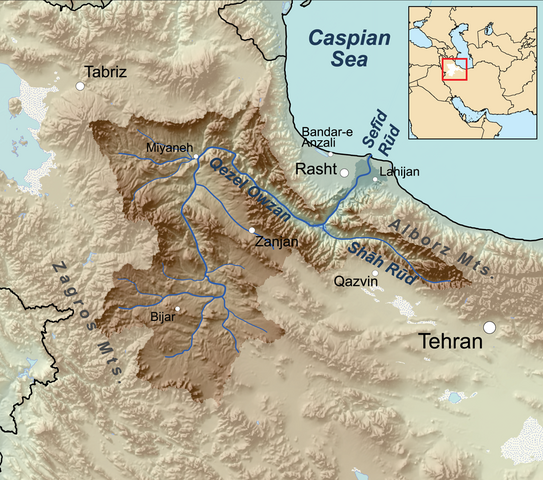
| current | 03:12, 26 March 2011 | | 1,000 × 884 (1.22 MB) | Kmusser | == Summary == {{Information |Description=Map showing the Sefīd-Rūd drainage basin in Iran. |Source={{own}}, Elevation data from SRTM, drainage basin from GTOPO [http://eros.usgs.gov/#/Find_D |
File usage
The following 3 pages use this file:
Global file usage
The following other wikis use this file:
- Usage on azb.wiki.x.io
- Usage on az.wiki.x.io
- Usage on ceb.wiki.x.io
- Usage on ckb.wiki.x.io
- Usage on cs.wiki.x.io
- Usage on de.wiki.x.io
- Usage on en.wiktionary.org
- Usage on es.wiki.x.io
- Usage on fa.wiki.x.io
- Usage on fr.wiki.x.io
- Usage on hy.wiki.x.io
- Usage on it.wiki.x.io
- Usage on ja.wiki.x.io
- Usage on ka.wiki.x.io
- Usage on ml.wiki.x.io
- Usage on no.wiki.x.io
- Usage on ru.wiki.x.io
- Usage on uk.wiki.x.io
- Usage on www.wikidata.org