
File:Pacifico1879.svg

Size of this PNG preview of this SVG file: 415 × 600 pixels. Other resolutions: 166 × 240 pixels | 332 × 480 pixels | 531 × 768 pixels | 708 × 1,024 pixels | 1,417 × 2,048 pixels | 570 × 824 pixels.
Original file (SVG file, nominally 570 × 824 pixels, file size: 51 KB)
| This is a file from the Wikimedia Commons. Information from its description page there is shown below. Commons is a freely licensed media file repository. You can help. |
Summary
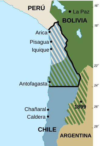
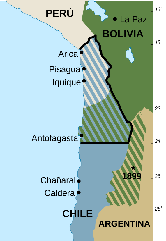
| Description | Mapa de las fronteras entre Bolivia, Chile y Perú actuales y anteriores a la Guerra del Pacífico de 1879. Versión vectorizada en español. Basado en Image:Borders-Bolivia-Chile-Peru-Before and after Pacfic War of 1879 SP.png |
| Date | |
| Source | Own work |
| Author | User_talk:Ummowoa |
| Permission (Reusing this file) |
Public domain |
| Other versions |
 |
Licensing
| I, the copyright holder of this work, release this work into the public domain. This applies worldwide. In some countries this may not be legally possible; if so: I grant anyone the right to use this work for any purpose, without any conditions, unless such conditions are required by law. |
File history
Click on a date/time to view the file as it appeared at that time.
| Date/Time | Thumbnail | Dimensions | User | Comment | |
|---|---|---|---|---|---|
| current | 12:07, 2 March 2016 | | 570 × 824 (51 KB) | Rowanwindwhistler | Font workaround |
| 12:06, 2 March 2016 |  | 570 × 824 (51 KB) | Rowanwindwhistler | Resized | |
| 12:04, 2 March 2016 |  | 595 × 842 (52 KB) | Rowanwindwhistler | Text into real, text, coast, sea colour from http://en.wiki.x.io/wiki/Wikipedia:WikiProject_Maps/Conventions | |
| 07:48, 31 May 2007 |  | 595 × 842 (60 KB) | Ummowoa | Fixing transparency | |
| 07:45, 31 May 2007 |  | 595 × 842 (60 KB) | Ummowoa | ||
| 07:34, 31 May 2007 |  | 590 × 841 (98 KB) | Ummowoa | {{Information |Description=Mapa de las fronteras entre Bolivia, Chile y Perú actuales y anteriores a la Guerra del Pacífico de 1879. Versión vectorizada en español. |Source= Own work |Date= 31 de mayo 2007 |Author= User:Ummowoa |Permission= Public |
File usage
The following pages on the English Wikipedia use this file (pages on other projects are not listed):
Global file usage
The following other wikis use this file:
- Usage on af.wiki.x.io
- Usage on ar.wiki.x.io
- Usage on ast.wiki.x.io
- Usage on cs.wiki.x.io
- Usage on es.wiki.x.io
- Usage on es.wikinews.org
- Usage on es.wiktionary.org
- Usage on fr.wiki.x.io
- Usage on gl.wiki.x.io
- Usage on hu.wiki.x.io
- Usage on id.wiki.x.io
- Usage on io.wiki.x.io
- Usage on it.wiki.x.io
- Usage on ka.wiki.x.io
- Usage on krc.wiki.x.io
- Usage on pt.wiki.x.io
- Usage on pt.wikinews.org
- Usage on simple.wiki.x.io
- Usage on sl.wiki.x.io
- Usage on uk.wiki.x.io