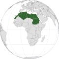
File:North Africa (orthographic projection).svg
Appearance

Size of this PNG preview of this SVG file: 600 × 600 pixels. Other resolutions: 240 × 240 pixels | 480 × 480 pixels | 768 × 768 pixels | 1,024 × 1,024 pixels | 2,048 × 2,048 pixels | 733 × 733 pixels.
Original file (SVG file, nominally 733 × 733 pixels, file size: 161 KB)
File history
Click on a date/time to view the file as it appeared at that time.
| Date/Time | Thumbnail | Dimensions | User | Comment | |
|---|---|---|---|---|---|
| current | 16:59, 6 December 2020 |  | 733 × 733 (161 KB) | M.Bitton | Reverted to version as of 01:02, 16 November 2019 (UTC): North Africa is a group of countries that are separated by borders |
| 16:20, 6 December 2020 |  | 501 × 501 (196 KB) | Taha Khattabi | Centered Projection. Added Sinai Peninsula in light green because it is politically part of Africa (Egypt). Sudan in light green because it's considered as East Africa by the AU. If anybody can thicken the borders in the green countries and re-upload that would be great. | |
| 01:02, 16 November 2019 |  | 733 × 733 (161 KB) | Afrogindahood | Excluded Sinai peninsula which is a part of Asia | |
| 14:15, 30 December 2018 |  | 550 × 550 (123 KB) | Wadaad | UN geoscheme and the most common understanding of the term. | |
| 03:39, 21 December 2012 |  | 550 × 550 (167 KB) | Spacepotato | Recolor South Sudan, since in the current version of the UN geographic classification scheme, http://unstats.un.org/unsd/methods/m49/m49regin.htm , South Sudan has been placed in Eastern Africa. | |
| 17:02, 25 September 2011 |  | 550 × 550 (168 KB) | Night w | adding back s.sudan under un def.; adding back saharan countries under geo def. | |
| 20:58, 19 August 2011 |  | 550 × 550 (167 KB) | Yabroq | Thickened borders | |
| 16:35, 19 August 2011 |  | 550 × 550 (167 KB) | Yabroq | Removed South Sudan. Removed West and Eastern Africa Which is not North Africa | |
| 02:11, 15 January 2010 |  | 550 × 550 (172 KB) | Connormah | {{Information |Description={{en|1=North Africa }} |Source=Based off File:Africa (orthographic projection).svg, File:LocationNorthernAfrica.png |Author=Connormah |Date= |Permission= |other_versions= }} |
File usage
The following 6 pages use this file:
Global file usage
The following other wikis use this file:
- Usage on af.wiki.x.io
- Usage on am.wiki.x.io
- Usage on ar.wiki.x.io
- Usage on azb.wiki.x.io
- Usage on az.wiki.x.io
- Usage on bn.wiki.x.io
- Usage on br.wiki.x.io
- Usage on ckb.wiki.x.io
- Usage on da.wiki.x.io
- Usage on el.wiki.x.io
- Usage on en.wiktionary.org
- Usage on fa.wiki.x.io
- Usage on fi.wiki.x.io
- Usage on fr.wiki.x.io
- Usage on ga.wiki.x.io
- Usage on gv.wiki.x.io
- Usage on hi.wiki.x.io
- Usage on ht.wiki.x.io
- Usage on hu.wikibooks.org
- Usage on id.wiki.x.io
- Usage on ilo.wiki.x.io
- Usage on incubator.wikimedia.org
- Usage on io.wiki.x.io
- Usage on ja.wiki.x.io
- Usage on kg.wiki.x.io
- Usage on ko.wiki.x.io
- Usage on lad.wiki.x.io
- Usage on la.wiki.x.io
- Usage on ln.wiki.x.io
- Usage on lt.wiki.x.io
- Usage on mdf.wiki.x.io
- Usage on mi.wiki.x.io
- Usage on mk.wiki.x.io
- Usage on ml.wiki.x.io
- Usage on mn.wiki.x.io
- Usage on nl.wiki.x.io
- Usage on no.wiki.x.io
View more global usage of this file.


