Jump to content

File:Mada'in Saleh 2017.jpg

Page contents not supported in other languages.
This is a file from the Wikimedia Commons
From Wikipedia, the free encyclopedia

Original file (7,360 × 4,912 pixels, file size: 26.47 MB, MIME type: image/jpeg)

Summary

Description
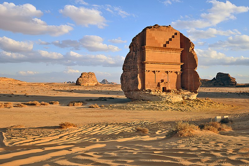
العربية: مدائن صالح موقع أثري يقع بمحافظة العلا ضمن إمارة المدينة المنورة، الحجاز، المملكة العربية السعودية. تعود غالبية الآثار إلى مملكة الأنباط (القرن الأول الميلادي).
English: Mada'in Saleh is an archaeological site located in the Sector of Al-`Ula within the Province of Al-Madinah, the Hejaz, Saudi Arabia. A majority of the vestiges date from the Nabatean kingdom (1st century AD). I believe and I'm sure I took that picture in Madain Saled on February, 19, 2017. and I'm responsible of that picture, it has copyright of Ahmad Hasanat
Date
Source Own work
Author Ahmad AlHasanat
OpenStreetMap
InfoField
Way 639423413
Object location26° 46′ 26.35″ N, 37° 57′ 40.34″ E Kartographer map based on OpenStreetMap.View this and other nearby images on: OpenStreetMapinfo
Quality image
Quality image

Wikimedia CommonsWikipedia

This is a quality image and is considered to meet the quality image guidelines.

 This is a featured picture on the Arabic language Wikipedia (صور مختارة) and is considered one of the finest images. See its nomination here.

If you think this file should be featured on Wikimedia Commons as well, feel free to nominate it.
If you have an image of similar quality that can be published under a suitable copyright license, be sure to upload it, tag it, and nominate it.

Licensing

I, the copyright holder of this work, hereby publish it under the following license:
w:en:Creative Commons
attribution share alike
This file is licensed under the Creative Commons Attribution-Share Alike 4.0 International license.
You are free:
  • to share – to copy, distribute and transmit the work
  • to remix – to adapt the work
Under the following conditions:
  • attribution – You must give appropriate credit, provide a link to the license, and indicate if changes were made. You may do so in any reasonable manner, but not in any way that suggests the licensor endorses you or your use.
  • share alike – If you remix, transform, or build upon the material, you must distribute your contributions under the same or compatible license as the original.

Captions

Qasr al-Farid (meaning 'Lonely Castle') at the archaeological site of Madâin Sâlih in northern Saudi Arabia

Items portrayed in this file

depicts

16 February 2017

26°46'26.3471"N, 37°57'40.3394"E

0.002 second

35 millimetre

image/jpeg

27,759,860 byte

4,912 pixel

7,360 pixel

e110c450577be09e73fc00d75d7b54afa0caab25

File history

Click on a date/time to view the file as it appeared at that time.

Date/TimeThumbnailDimensionsUserComment
current16:39, 11 September 2017Thumbnail for version as of 16:39, 11 September 20177,360 × 4,912 (26.47 MB)AlhasaamUser created page with UploadWizard

The following page uses this file:

Global file usage

The following other wikis use this file:

Metadata