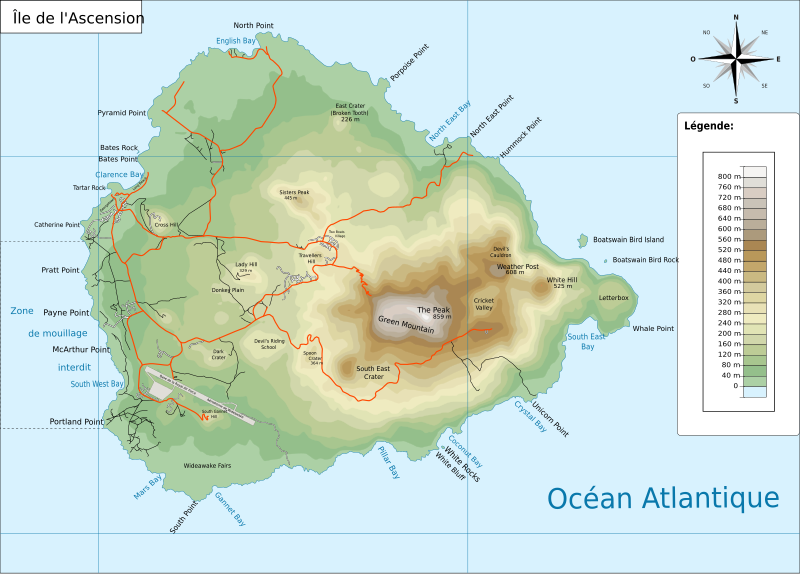
File:Ile de l'ascension routes.svg
Appearance

Size of this PNG preview of this SVG file: 800 × 573 pixels. Other resolutions: 320 × 229 pixels | 640 × 458 pixels | 1,024 × 734 pixels | 1,280 × 917 pixels | 2,560 × 1,834 pixels | 2,101 × 1,505 pixels.
Original file (SVG file, nominally 2,101 × 1,505 pixels, file size: 1.31 MB)
File history
Click on a date/time to view the file as it appeared at that time.
| Date/Time | Thumbnail | Dimensions | User | Comment | |
|---|---|---|---|---|---|
| current | 09:17, 13 October 2010 |  | 2,101 × 1,505 (1.31 MB) | Treehill | ajout des noms des deux villages et de la base de la royal air force |
| 18:58, 12 October 2010 |  | 2,101 × 1,505 (1.3 MB) | Treehill | {{Information |Description={{fr|1=Carte presque vierge de l'Île de l'Ascension.}} |Source=*File:Ile_de_l'ascension.svg * [http://www.openstreetmap.org/index.html?mlat=-7.9333&mlon=-14.3666&zoom=17&layers=M Map for free] |
File usage
The following 4 pages use this file:
Global file usage
The following other wikis use this file:
- Usage on af.wiki.x.io
- Usage on als.wiki.x.io
- Usage on ar.wiki.x.io
- Usage on arz.wiki.x.io
- Usage on ast.wiki.x.io
- Usage on bg.wiki.x.io
- Usage on br.wiki.x.io
- Usage on bs.wiki.x.io
- Usage on ca.wiki.x.io
- Usage on cy.wiki.x.io
- Usage on eo.wiki.x.io
- Usage on es.wiki.x.io
- Usage on eu.wiki.x.io
- Usage on fa.wiki.x.io
- Usage on fr.wiki.x.io
- Usage on gl.wiki.x.io
- Usage on hy.wiki.x.io
- Usage on id.wiki.x.io
- Usage on it.wiki.x.io
- Usage on ja.wiki.x.io
- Usage on lv.wiki.x.io
- Usage on ml.wiki.x.io
- Usage on nds-nl.wiki.x.io
- Usage on nl.wiki.x.io
- Usage on nn.wiki.x.io
- Usage on or.wiki.x.io
- Usage on pnb.wiki.x.io
- Usage on pt.wiki.x.io
- Usage on ro.wiki.x.io
View more global usage of this file.

