Jump to content

File:Diseño Butano.jpg

Page contents not supported in other languages.
This is a file from the Wikimedia Commons
From Wikipedia, the free encyclopedia

Original file (2,018 × 2,240 pixels, file size: 806 KB, MIME type: image/jpeg)

Summary

Description
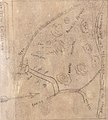
English: The grant extended along the Pacific coast between Rancho Pescadero and Rancho Punta del Año Nuevo, with Butano Creek on the north to Arroyo de los Frijoles (Creek of the Beans) on the south, and encompassed present-day Bean Hollow State Beach and Butano State Park
Date
Source Butano Diseño
Author Ramona Sanchez or copied from his original
Camera location37° 29′ 13.91″ N, 122° 13′ 46.03″ W  Heading=191.46469° Kartographer map based on OpenStreetMap.View this and other nearby images on: OpenStreetMapinfo

Licensing

Public domain

This work is in the public domain in its country of origin and other countries and areas where the copyright term is the author's life plus 70 years or fewer.


This work is in the public domain in the United States because it was published (or registered with the U.S. Copyright Office) before January 1, 1929.

This file has been identified as being free of known restrictions under copyright law, including all related and neighboring rights.

Captions

To obtain a land grant during the Mexican period, the applicant accompanied the petition with a topographical sketch or diseño. Mexican law did not require precision surveying.

Items portrayed in this file

depicts

37°29'13.909"N, 122°13'46.031"W

heading: 191.46469 degree

0.05 second

4.15 millimetre

image/jpeg

File history

Click on a date/time to view the file as it appeared at that time.

Date/TimeThumbnailDimensionsUserComment
current23:23, 24 March 2019Thumbnail for version as of 23:23, 24 March 20192,018 × 2,240 (806 KB)FAHanssonUser created page with UploadWizard

The following page uses this file:

Metadata