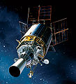
File:DSP Phase3.jpg
Appearance

Size of this preview: 545 × 600 pixels. Other resolutions: 218 × 240 pixels | 575 × 633 pixels.
Original file (575 × 633 pixels, file size: 344 KB, MIME type: image/jpeg)
File history
Click on a date/time to view the file as it appeared at that time.
| Date/Time | Thumbnail | Dimensions | User | Comment | |
|---|---|---|---|---|---|
| current | 12:43, 10 August 2007 |  | 575 × 633 (344 KB) | GDK | cropped version |
| 15:01, 23 July 2006 |  | 1,200 × 928 (755 KB) | Bricktop | better quality | |
| 18:11, 21 July 2006 |  | 400 × 400 (16 KB) | Bricktop | {{Information |Description=Defense Support Program |Source=http://www.afrl.af.mil/images_satellites.asp <br> http://www.afrl.af.mil/images/pictures/dsp.jpg |Date= |Author=USAF |Permission= |other_versions= }} {{PD-USGov-Military-Air Force}} [[Category:M |
File usage
The following 6 pages use this file:
Global file usage
The following other wikis use this file:
- Usage on ar.wiki.x.io
- Usage on de.wiki.x.io
- Usage on es.wiki.x.io
- Usage on et.wiki.x.io
- Usage on fi.wiki.x.io
- Usage on fr.wiki.x.io
- Usage on it.wiki.x.io
- Usage on ja.wiki.x.io
- Usage on ko.wiki.x.io
- Usage on pt.wiki.x.io
- Usage on ru.wiki.x.io
- Usage on simple.wiki.x.io
- Usage on szy.wiki.x.io
- Usage on uk.wiki.x.io
- Usage on zh.wiki.x.io

