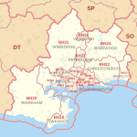
File:BH-Postcodes.png
Appearance
BH-Postcodes.png (542 × 482 pixels, file size: 75 KB, MIME type: image/png)
File history
Click on a date/time to view the file as it appeared at that time.
| Date/Time | Thumbnail | Dimensions | User | Comment | |
|---|---|---|---|---|---|
| current | 14:08, 8 February 2010 |  | 542 × 482 (75 KB) | Mahahahaneapneap | Compressed |
| 19:20, 19 January 2009 |  | 542 × 482 (76 KB) | Fluteflute | == Summary == {{Information |Description={{en|1=Map to show codes for the BH postcode area,}} |Source=http://dev.openstreetmap.org/~random/postcodes/?zoom=10&lat=50.73859&lon=-2.00844&layers=B00T0F |Author=OSM & contributors & NPE maps |Date=Jan 2009 |Per |
File usage
The following page uses this file:


